Sunday, 1 March 2020

Bats, Badgers, Boars, Beavers and Bunnies (+ the odd hare)

I have seen real wild bats, badgers, bunnies and hares in Somerset but I have not yet seen a beaver or a wild boar.  I found these creatures in churches, churchyards, meadows, woods, lanes and adorning walls at various locations across Somerset.  

The Belfry, near Priddy
This is the headquarters of the Bristol Exploration Club

Bat mural, Grange Drive, Taunton
Along with three other wildlife murals (a hedgehog, two watervoles and some bees), this bat mural was painted in August 2015 by Brazilian artist Louis Masai.  The North Taunton Art Trail was part of Somerset Wildlife Trust's Routes to the River Tone Project.

Bat carved into a bench end at Crowcombe  Church

Bat carved into a seat in Middlezoy Churchyard

Badgers Cross Farm, Mill Lane, south of Somerton

Badger carved in Hamstone on a footpath near Chiselborough

Badgers Holt pub, Bridgetown

Badger in the churchyard at Oake

Two badgers (and a robin and some Exmoor ponies) on a stained glass window in Winsford Church

Two rabbits (and a stag) on a stained glass window in Winsford Church

West door of Norton-sub-Hamdon Church
I think this is a rabbit?

Rabbit (and hedgehog) Oake Churchyard

Beaver at the deserted village of Clicket
His purpose in life is to be a target for field archery practice!

Wild boar in Barrington

Boxing hares willow sculpture, Steart Marshes

Hare, Ashill

Hare chainsaw sculpture, Croydon Hill Woods

Hare on the gravestone of Mr William Steuart Hare in the churchyard of St Michael & All Angels Church in Stawley

Boxing hares at Steart Marshes

Hares' Moon mural, Hill Head, Glastonbury


Rather worn wooden sculptures of a rabbit and a badger at Splash Point, Watchet

Rabbit roundel at Splash Point, Watchet

Badger at the bus stop in Higher Road, Woolavington

Badger, Forefront Community Centre & Church, Fore Street, Chard

Rabbit, Forefront Community Centre & Church, Fore Street, Chard

Victoria Park, Frome
This animal themed bench, which features three bats and three badgers, was made from a 140 year old Norway maple, which had to be felled in 2025 because it was diseased.  The bench was made by Graham Derham.

Bats and badgers, Victoria Park, Frome

Friday, 14 February 2020

Mary Bridge's Sword

11 or 12 year old Mary Bridge was living with her family in Westonzoyland in July 1685 at the time of the defeat of the Duke of Monmouth at the Battle of Sedgemoor.  After the battle a Royalist officer was billeted with them.  When he attempted to rape her mother, Mary drew the soldier's sword and killed him with it by stabbing him in the heart.  She was tried in front of Colonel Kirke but was acquitted.  He gave her the sword to keep and it was handed down the generations before being given to the Museum of Somerset.


Mary Bridge's Sword on display at the Museum of Somerset

Saturday, 1 February 2020

Conjoined twins - Priscilla & Aquila Herring and the Fair Maids of Foscott

On 19th May 1680 Mrs Herring, the wife of a farm labourer in Isle Brewers, gave birth to conjoined twins.  They were joined together back to back from their nipples to their navels (xiphopagus) but were otherwise healthy.  

 On 29th May 1680 the twins were baptised by the Reverend Andrew Paschall, who was the vicar of Chedzoy and they were named Priscilla and Aquila.  The vicar was superstitious and considered the twins' birth to be a sign of impending evil: he thought he had been proved right when the Duke of Monmouth invaded England in 1685. 

Later in 1680 a man in the Taunton area wrote a pamphlet or 'broadside' about the birth of the twins.  This was printed and sold in London.  Hundreds of people visited Isle Brewers to see Priscilla and Aquila.  A commemorative plate made of yellow glazed red pitcher clay and decorated using the sgraffito technique was produced, probably in Crock Street, Ilminster.  The plate was probably sold to some of the people who visited the twins.  One of the plates can be seen on display in the Rebellion section of the Museum of Somerset in Taunton.


Commemorative plate on display in the Museum of Somerset

Henry Walrond lived at Walrond Hall near Isle Brewers and was a local Justice of the Peace.  He persecuted the local Quakers but was in financial difficulties.  Together with Sir Edward Phelips of Montacute House he abducted Priscilla and Aquila from their parents, so he could make money for himself by exhibiting them.  The twins probably died in about 1683. It is not known whether they died of natural causes or mistreatment.

Conjoined twins known as the Fair Maids of Foscott are commemorated in the Church of St Philip and St James in Norton St Philip.  They were apparently born (the date is unknown) in the hamlet of Foscott/Foscote (now called Foxcote).  They had two heads but only one pair of legs (dicephalus).  They lived into adulthood but nothing else is known about them.  In 1668 Samuel Pepys visited the church in Norton St Philip and commented on the tombstone of the twins.


Stone effigies of the Fair Maids of Foscott in the church at Norton St Philip with the quotation from Samuel Pepys' Diary underneath

Monday, 13 January 2020

Plague victims in East Coker

Between June and September 1645 seventy villagers in East Coker, including Archdeacon Helyar and the Vicar, died of plague. They were buried in a communal grave just outside the churchyard in East Coker.  In 2003 a gravestone was erected in their memory.

Memorial to the plague victims of East Coker

Plague burial site and memorial

Wednesday, 1 January 2020

Burrow Mump

Burrow Mump is a natural hill of Mercia Mudstone, which rises dramatically from the flat landscape of the Somerset Moors at Burrowbridge, although it is only 24 metres higher than the surrounding land.  It has a flat top, below which the sides have been steeply scarped for about 7 metres. The lower slopes of the hill are natural.   

Burrow Mump is located at a strategic point where the River Tone and the old course of the River Cary join the River Parrett. According to local legend, King Alfred used the hill as a defensive position against the Danes, but there is no evidence that this was true.  It may also have been the site of a Norman motte and bailey castle.  It was owned by Athelney Abbey from around 937 AD.

In medieval times a chapel dedicated to St Michael was built on top of Burrow Mump.  It was rebuilt several times and was still standing in the mid-17th century.  During the English Civil War, Royalist troops occupied Burrow Mump in 1642 and for three days in 1645, after losing the Battle of Langport.  By the mid-18th century the chapel was in ruins and in 1793 rebuilding commenced, but the church was never completed.  The church is built of lias with Ham stone and red brick dressings.  In 1836-8 a church (also dedicated to St Michael) was built at the foot of the hill in the village of Burrowbridge instead.

Burrow Mump and the unfinished church were given to the National Trust by Major Alexander Gould Barrett in 1946, as a memorial to the Somerset men and women who lost their lives during the Second World War.  There is a small car park located just off the A361 to the east of Burrow Mump.

St Michael's Church

St Michael's Church

Inside St Michael's Church

St Michael's Church

View across the Levels from St Michael's Church

War memorial plaque

Burrow Mump at sunset

Burrow Mump just after sunset

Burrow Mump in the twilight

Saturday, 14 December 2019

The Shambles, Shepton Mallet

Shamble is a medieval term for "a table or stall for the sale of meat" (Oxford English Dictionary).  The word comes from the Latin word scamellum, meaning "bench".  In the 14th and 15th centuries most country towns would have had shambles.  The most famous Shambles are in York: this was where the city's butchers lived and sold their meat in the Middle Ages.  When open markets declined, as shops became more common in the 19th century, the shambles in almost all towns were dismantled. 

At the east end of the Market Place in Shepton Mallet stands a restored and re-erected bay of the town's 15th century shambles.  They are made of oak and have a pantiled roof.  The shambles originally stood along the north and south sides of the market place and were separated from the adjacent houses by a 10-15 feet wide gangway.  The shambles on the south side were demolished in the early 19th century but those on the north side survived until 1919.  


Shambles in Shepton Mallet Market Place

Sunday, 1 December 2019

Brean Down Fort

Brean Down is a headland, which juts out into the Bristol Channel at the eastern end of Bridgwater Bay.  It is composed of carboniferous limestone and is a continuation of the Mendip Hills (as are the islands of Steep Holm and Flat Holm).  The highest point on Brean Down is 97 metres above sea level and this is marked by a trig point. The name Brean probably comes from the Ancient British word briga, meaning hill.

Brean Down has been occupied for different purposes for thousands of years:
  •  Neolithic people lived and farmed there.
  •  Bronze Age people lived, farmed and buried their dead on it.
  •  A hillfort was built on it by Iron Age people.
  •  A temple and a settlement were built on it in Roman times.
  •  In the post Roman period people buried their dead in a cemetery on it.
  •  From the 14th to the 18th centuries it was managed as a rabbit warren.
  •  In Victorian times a fort was built at the western end and work on a harbour was started in 1864 but never completed.
  •  It was fortified during the Second World War.
In the 1850s concern grew in Britain about the strength of the French Navy and it was believed that war between France and Britain might be imminent.  Henry John Temple, 3rd Viscount Palmerston, became Prime Minister for the 2nd time in 1859. Palmerston and his Secretary of State for War (Sidney Herbert) established a Royal Commission on the Defence of the United Kingdom in 1859 to examine the ability of Britain to defend itself against an attempted invasion by a foreign power and to advise the British Government on the remedial action required. 

The Commission reported back in 1860 and recommended the building of forts to protect naval bases and other strategic locations around the coasts of Britain and Ireland.  In the Bristol Channel Brean Down, Steep Holm, Flat Holm and Lavernock Point were to be fortified in order to protect the ports of Bristol, Avonmouth, Cardiff and Newport.

In 1862 four acres of land at the western end of Brean Down were requisitioned from the Wyndham family, who had owned it since the 17th century when they bought it from Glastonbury Abbey.  In 1864 Lieutenant Robert Vetch was given the task of constructing the Bristol Channel forts.  Brean Down Fort was completed by 1870 but was not equipped with artillery straightaway.  It was partially concealed on the seaward side and the landward side was protected by a dry moat.  By 1872 a garrison of 51 soldiers were living there.  Seven 7" cannons were installed by the late 1870s.  These were located in three batteries:
  •  West Battery - this had 3 cannons and 2 underground magazines
  •  North West Battery - this had 3 cannons and 2 underground magazines
  •  North East Battery - this had 1 cannon and a magazine
There were also barracks, a guard house, a master-gunner's quarters and an officers' mess.  

Both Viscount Palmerston and Sidney Herbert died before work began on Brean Down Fort. By the time the fortifications were completed, the threat from the French had diminished. The island’s heavy guns were never fired in anger.  

In July 1900 a soldier called William Haines fired his rifle into one of the West Battery's magazines, in an apparent attempt to kill himself, and it exploded and destroyed the battery.  After the explosion the fort was decommissioned and the guns were sold for scrap in 1901. In 1909 Brean Down Fort was handed back to the Wyndham family.   

In 1910 part of the fort was converted into a café , which was run by Mr R. Waterman.  The fort was not used during the First World War.  In the early 1920s the Wyndham's leased the fort to Joseph Chamberlain, who opened it as a café, which was run by Alfred Meredith and his wife. Many visitors arrived via the Uphill Ferry or on boats from Anchor Head or Knightstone Harbour in Weston-super-Mare.  The Merediths closed the café in 1936.

Brean Down Fort was refortified in 1941-42.  Two gun positions were built: one on the site of the ruined West Battery and the other over part of the North West Battery.  They were armed with 6" ex-naval guns.  

Two Coastal Artillery Searchlight posts were built - one on the western tip of Brean Down and the other on the cliff top to the south of the fort.  These were made of reinforced concrete and were covered with camouflage paint. The searchlights were protected by armoured steel shutters.  They could scan the sea for enemy ships at radius of two miles.

The Victorian barracks were reused as a canteen and leisure room, but the windows were partly blocked to give protection from blasts.  The officers were accommodated in the former Master-Gunner's quarters.  12 Nissen huts were built in the old quarry on the east side of the Victorian fort and used as barracks.  

A battery of 6 Lewis guns was built on the north side of Brean Down, close to the Iron Age hillfort.

During the Second World War experimental weapons were tested at the fort by scientists from the Admiralty Department of Miscellaneous Weapons Development, who were based at HMS Birnbeck. The short length of launching rail, which can still be seen, is evidence of these trials.  This was used to launch a 'bouncing bomb'.

At the end of 1943 Brean Down Fort was downgraded to "care and maintenance" and the guns were removed in 1945 and the land was returned to the ownership of the Wyndham Trust.

Axbridge Rural District Council bought most of Brean Down (except the fort) from the Wyndham Trust in 1954 and then gave it (147.5 acres) to the National Trust. Weston-super-Mare Borough Council bought the fort from the Wyndham Trust and they considered various future uses for the fort e.g. a casino or a centre for youth activities but all were rejected. In 1958-9 parts of the fort were dismantled and the rest of it was cleared of miscellaneous debris and undergrowth by groups of volunteers. In 1973 Weston-super-Mare Borough Council offered the fort to the National Trust but they wouldn't accept it because they didn't want to pay for its repair and maintenance, so they sold it to Axbridge Rural District Council for a nominal fee.  

 In 1977 the army were brought in to blow up the roofs of the two Second World War gun emplacements, as they were in a dangerous condition.  In 1983 a Manpower Services Commission team were employed to make the fort buildings safe. 

Various councils and organisations produced reports and plans for the future conservation and development of the fort over the years.  Between 1994 and 1997, Sedgemoor District Council (the successor council to Axbridge Rural District), the National Trust and English Heritage worked together on an application for a grant from the Heritage Lottery Fund to restore the fort and convert the buildings into a museum, holiday accommodation a café and a shop, but the National Trust withdrew their support at the last minute and the application was rejected in March 1998.

In December 1998 the National Trust submitted their own application to the Heritage Lottery Fund for a grant of £350,000 to pay for the repair and stabilisation of the fort.  They were told in August 1999 that their application was successful.  In 2000 3.4 acres at Brean Down Cove were acquired by the National Trust from MD & M Matthews.  In 2002, following renovation work, Sedgemoor District Council gave Brean Down Fort to the National Trust.

Further reading:

Brean Down Fort: Its History and the Defence of the Bristol Channel by Nicholas van der Bijl, Hawk Editions, 2000

The south coast of Brean Down

Looking west down Brean Down

Trig point on Brean Down - looking north east across Weston Bay towards Worlebury Hill

Brean Down Fort

Victorian gun battery and entrance to one of the underground magazines

Second World War searchlight position at the west end of Brean Down


Second World War searchlight position and launching rail for experimental weapons

Searchlight position, Brean Down

Gun emplacement, Brean Down Fort

Inside the Victorian barrack room
This room was built to house 20 men, but for most of the time it was in use only 4 or 5 gunners lived there.  They had folding beds, which when folded up could be used as chairs.

Second World War Battery Command Post

World War Two Battery Command Post

Brean Down Fort

Brean Down Fort with the site of the Second World War barracks below it

Six Lewis gun emplacements on the north coast of the eastern end of Brean Down overlooking Weston Bay
These were possibly used for training purposes.

The South coast of Brean Down

Master Gunner's Quarters
This building was originally divided into 4 large rooms.  In 1881 it was occupied by Master Gunner John Bond.  His wife and children lived there with him.   During the Second World War when the building was used as an officers' mess, it was probably divided into 9 rooms.

Second World War searchlight position on the west end of Brean Down
Steep Holm can be seen in the distance.

Dry moat
Brean Down Fort is on the left hand side of the photo

Thursday, 14 November 2019

Monkey Bridge, Tickenham

In 2013 Tickenham Parish Council erected a plaque on the bridge to the south west of the parish church and on the unclassified road that runs south to Nailsea across Tickenham Moor.  The wording on the plaque reads as follows:

Monkey Bridge (formerly Church Bridge)

On Tuesday 13th March 1906 Bostock and Wombwell’s Travelling Menagerie attempted to cross this bridge having already failed to climb the main road by Jacklands Bridge because of ice. The horse-drawn carriage with monkeys on board fell into the rhyne: the elephants and horses tried but failed to free the wagon.  Eventually a local traction engine succeeded and they continued on their way to Clevedon that night.  All animals are believed to have survived the incident.

Plaque on Monkey Bridge

Monkey Bridge looking north east toward the Church of St Quiricus and St Julietta

Monkey Bridge looking south towards Nailsea across Tickenham Moor

Friday, 1 November 2019

The Herbert Memorial Chapel, Church of St Nicholas, Brushford

Aubrey Nigel Henry Molyneux Herbert, who was born on 3rd April 1880 at Highclere Castle in Hampshire, was the son of Henry, 4th Earl of Carnarvon and his second wife Elizabeth Howard.  George Herbert, the 5th Earl of Carnarvon, who discovered the tomb of Tutankhamun, was his half brother.  In 1910 Aubrey Herbert married Mary Vesey, daughter of Ivo, 4th Viscount de Vexi.  They had a son and three daughters.  At the time of his marriage his mother gave him the estate of Pixton Park near Brushford, as well as a property in Portofino, Italy.

Aubrey Herbert was the Conservative (and later independent) MP for South Somerset from 1911-1918 and for Yeovil from 1918 until his death. He spoke several European languages fluently and travelled extensively in Turkey and the Balkans.  He advocated Albanian independence and was partly responsible for the creation of the independent state of Albania after the First World War.  He was twice offered the throne of Albania but declined it on both occasions.

Despite having very poor eyesight Aubrey Herbert joined the Irish Guards in 1914 and served with them in France.  He later worked in intelligence in Italy, Greece, Turkey, Egypt and Mesopotamia. He was a friend and ally of T.E. Lawrence.   He was also a friend of the author John Buchan, who based the hero in his novel Greenmantle on Aubrey Herbert.  

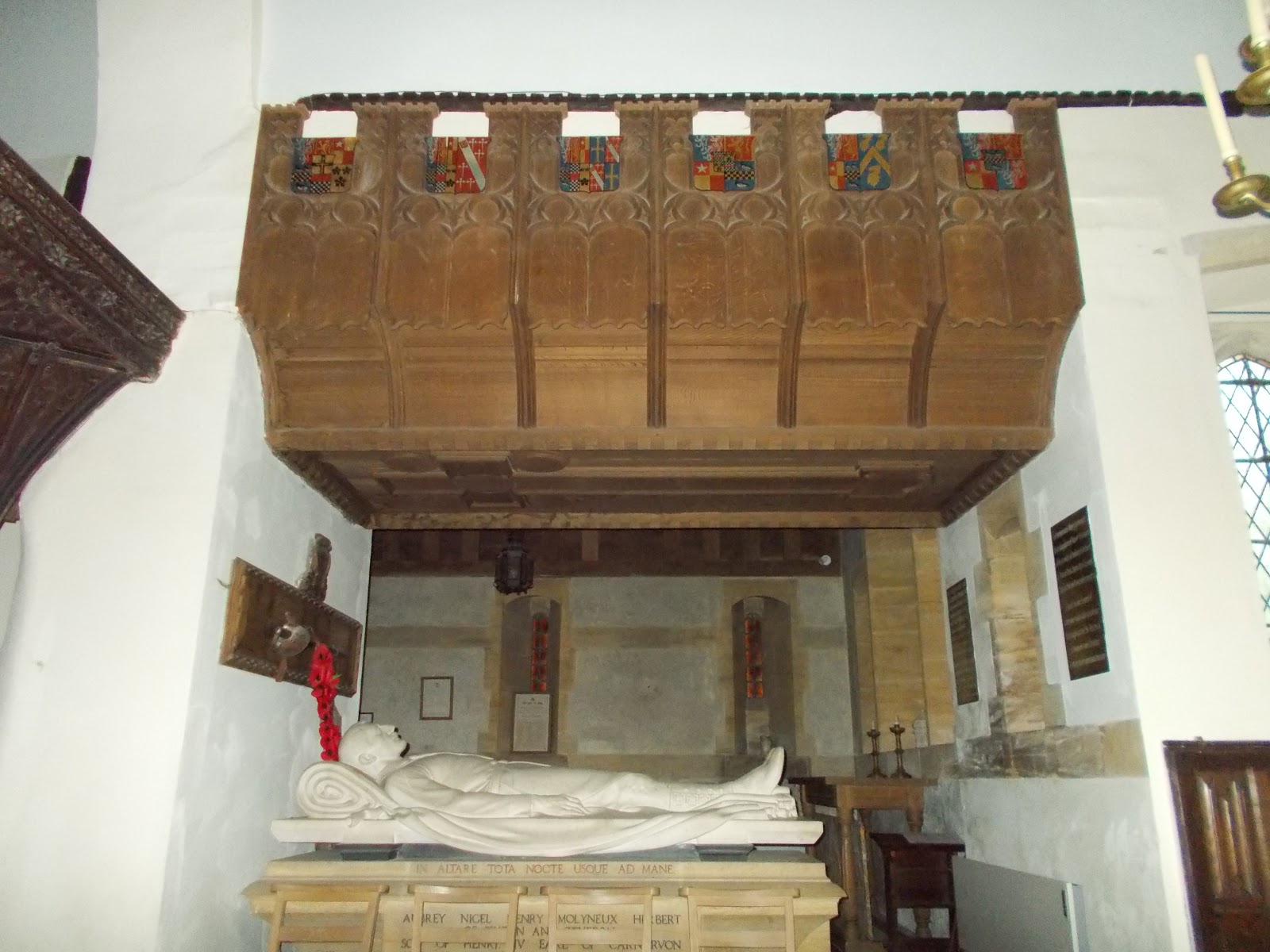
Aubrey Herbert died in London from blood poisoning on 26th September 1923.  Sir Edwin Lutyens was a friend of the Herbert family.  He designed a chapel as a memorial to Aubrey Herbert, which was built on to the north side of St Nicholas's Church in Brushford in 1926.  It has a cross shaped stained glass window at its east end.  

An effigy of Aubrey Herbert was made by Cecil de Banqueire (or de Blaquiere) Howard, an American sculptor who worked in Paris.  It is located at the south side of the Herbert Memorial Chapel.  It is hollow inside.

Cross window in the Herbert Memorial Chapel

Effigy of Aubrey Herbert in St Nicholas's Church, with a ceremonial sword above his head

Effigy of Aubrey Herbert

Effigy of Aubrey Herbert

Wooden canopy over Aubrey Herbert's effigy 
- this was also designed by Sir Edwin Lutyens

St Nicholas's Church, Brushford

12th century parish chest hollowed out of a single piece of oak.  It is now located in the corner of the Herbert Memorial Chapel. King Henry II (1154-1189) decreed that every parish should have a chest to collect contributions to pay for the Crusades.  These chests were later used for keeping books, documents and vestments safe.

Exterior of the Herbert Memorial Chapel

East end of the exterior of the Herbert Memorial Chapel showing the cross window