Saturday, 14 December 2019

The Shambles, Shepton Mallet

Shamble is a medieval term for "a table or stall for the sale of meat" (Oxford English Dictionary).  The word comes from the Latin word scamellum, meaning "bench".  In the 14th and 15th centuries most country towns would have had shambles.  The most famous Shambles are in York: this was where the city's butchers lived and sold their meat in the Middle Ages.  When open markets declined, as shops became more common in the 19th century, the shambles in almost all towns were dismantled. 

At the east end of the Market Place in Shepton Mallet stands a restored and re-erected bay of the town's 15th century shambles.  They are made of oak and have a pantiled roof.  The shambles originally stood along the north and south sides of the market place and were separated from the adjacent houses by a 10-15 feet wide gangway.  The shambles on the south side were demolished in the early 19th century but those on the north side survived until 1919.  


Shambles in Shepton Mallet Market Place

Sunday, 1 December 2019

Brean Down Fort

Brean Down is a headland, which juts out into the Bristol Channel at the eastern end of Bridgwater Bay.  It is composed of carboniferous limestone and is a continuation of the Mendip Hills (as are the islands of Steep Holm and Flat Holm).  The highest point on Brean Down is 97 metres above sea level and this is marked by a trig point. The name Brean probably comes from the Ancient British word briga, meaning hill.

Brean Down has been occupied for different purposes for thousands of years:
  •  Neolithic people lived and farmed there.
  •  Bronze Age people lived, farmed and buried their dead on it.
  •  A hillfort was built on it by Iron Age people.
  •  A temple and a settlement were built on it in Roman times.
  •  In the post Roman period people buried their dead in a cemetery on it.
  •  From the 14th to the 18th centuries it was managed as a rabbit warren.
  •  In Victorian times a fort was built at the western end and work on a harbour was started in 1864 but never completed.
  •  It was fortified during the Second World War.
In the 1850s concern grew in Britain about the strength of the French Navy and it was believed that war between France and Britain might be imminent.  Henry John Temple, 3rd Viscount Palmerston, became Prime Minister for the 2nd time in 1859. Palmerston and his Secretary of State for War (Sidney Herbert) established a Royal Commission on the Defence of the United Kingdom in 1859 to examine the ability of Britain to defend itself against an attempted invasion by a foreign power and to advise the British Government on the remedial action required. 

The Commission reported back in 1860 and recommended the building of forts to protect naval bases and other strategic locations around the coasts of Britain and Ireland.  In the Bristol Channel Brean Down, Steep Holm, Flat Holm and Lavernock Point were to be fortified in order to protect the ports of Bristol, Avonmouth, Cardiff and Newport.

In 1862 four acres of land at the western end of Brean Down were requisitioned from the Wyndham family, who had owned it since the 17th century when they bought it from Glastonbury Abbey.  In 1864 Lieutenant Robert Vetch was given the task of constructing the Bristol Channel forts.  Brean Down Fort was completed by 1870 but was not equipped with artillery straightaway.  It was partially concealed on the seaward side and the landward side was protected by a dry moat.  By 1872 a garrison of 51 soldiers were living there.  Seven 7" cannons were installed by the late 1870s.  These were located in three batteries:
  •  West Battery - this had 3 cannons and 2 underground magazines
  •  North West Battery - this had 3 cannons and 2 underground magazines
  •  North East Battery - this had 1 cannon and a magazine
There were also barracks, a guard house, a master-gunner's quarters and an officers' mess.  

Both Viscount Palmerston and Sidney Herbert died before work began on Brean Down Fort. By the time the fortifications were completed, the threat from the French had diminished. The island’s heavy guns were never fired in anger.  

In July 1900 a soldier called William Haines fired his rifle into one of the West Battery's magazines, in an apparent attempt to kill himself, and it exploded and destroyed the battery.  After the explosion the fort was decommissioned and the guns were sold for scrap in 1901. In 1909 Brean Down Fort was handed back to the Wyndham family.   

In 1910 part of the fort was converted into a café , which was run by Mr R. Waterman.  The fort was not used during the First World War.  In the early 1920s the Wyndham's leased the fort to Joseph Chamberlain, who opened it as a café, which was run by Alfred Meredith and his wife. Many visitors arrived via the Uphill Ferry or on boats from Anchor Head or Knightstone Harbour in Weston-super-Mare.  The Merediths closed the café in 1936.

Brean Down Fort was refortified in 1941-42.  Two gun positions were built: one on the site of the ruined West Battery and the other over part of the North West Battery.  They were armed with 6" ex-naval guns.  

Two Coastal Artillery Searchlight posts were built - one on the western tip of Brean Down and the other on the cliff top to the south of the fort.  These were made of reinforced concrete and were covered with camouflage paint. The searchlights were protected by armoured steel shutters.  They could scan the sea for enemy ships at radius of two miles.

The Victorian barracks were reused as a canteen and leisure room, but the windows were partly blocked to give protection from blasts.  The officers were accommodated in the former Master-Gunner's quarters.  12 Nissen huts were built in the old quarry on the east side of the Victorian fort and used as barracks.  

A battery of 6 Lewis guns was built on the north side of Brean Down, close to the Iron Age hillfort.

During the Second World War experimental weapons were tested at the fort by scientists from the Admiralty Department of Miscellaneous Weapons Development, who were based at HMS Birnbeck. The short length of launching rail, which can still be seen, is evidence of these trials.  This was used to launch a 'bouncing bomb'.

At the end of 1943 Brean Down Fort was downgraded to "care and maintenance" and the guns were removed in 1945 and the land was returned to the ownership of the Wyndham Trust.

Axbridge Rural District Council bought most of Brean Down (except the fort) from the Wyndham Trust in 1954 and then gave it (147.5 acres) to the National Trust. Weston-super-Mare Borough Council bought the fort from the Wyndham Trust and they considered various future uses for the fort e.g. a casino or a centre for youth activities but all were rejected. In 1958-9 parts of the fort were dismantled and the rest of it was cleared of miscellaneous debris and undergrowth by groups of volunteers. In 1973 Weston-super-Mare Borough Council offered the fort to the National Trust but they wouldn't accept it because they didn't want to pay for its repair and maintenance, so they sold it to Axbridge Rural District Council for a nominal fee.  

 In 1977 the army were brought in to blow up the roofs of the two Second World War gun emplacements, as they were in a dangerous condition.  In 1983 a Manpower Services Commission team were employed to make the fort buildings safe. 

Various councils and organisations produced reports and plans for the future conservation and development of the fort over the years.  Between 1994 and 1997, Sedgemoor District Council (the successor council to Axbridge Rural District), the National Trust and English Heritage worked together on an application for a grant from the Heritage Lottery Fund to restore the fort and convert the buildings into a museum, holiday accommodation a café and a shop, but the National Trust withdrew their support at the last minute and the application was rejected in March 1998.

In December 1998 the National Trust submitted their own application to the Heritage Lottery Fund for a grant of £350,000 to pay for the repair and stabilisation of the fort.  They were told in August 1999 that their application was successful.  In 2000 3.4 acres at Brean Down Cove were acquired by the National Trust from MD & M Matthews.  In 2002, following renovation work, Sedgemoor District Council gave Brean Down Fort to the National Trust.

Further reading:

Brean Down Fort: Its History and the Defence of the Bristol Channel by Nicholas van der Bijl, Hawk Editions, 2000

The south coast of Brean Down

Looking west down Brean Down

Trig point on Brean Down - looking north east across Weston Bay towards Worlebury Hill

Brean Down Fort

Victorian gun battery and entrance to one of the underground magazines

Second World War searchlight position at the west end of Brean Down


Second World War searchlight position and launching rail for experimental weapons

Searchlight position, Brean Down

Gun emplacement, Brean Down Fort

Inside the Victorian barrack room
This room was built to house 20 men, but for most of the time it was in use only 4 or 5 gunners lived there.  They had folding beds, which when folded up could be used as chairs.

Second World War Battery Command Post

World War Two Battery Command Post

Brean Down Fort

Brean Down Fort with the site of the Second World War barracks below it

Six Lewis gun emplacements on the north coast of the eastern end of Brean Down overlooking Weston Bay
These were possibly used for training purposes.

The South coast of Brean Down

Master Gunner's Quarters
This building was originally divided into 4 large rooms.  In 1881 it was occupied by Master Gunner John Bond.  His wife and children lived there with him.   During the Second World War when the building was used as an officers' mess, it was probably divided into 9 rooms.

Second World War searchlight position on the west end of Brean Down
Steep Holm can be seen in the distance.

Dry moat
Brean Down Fort is on the left hand side of the photo

Thursday, 14 November 2019

Monkey Bridge, Tickenham

In 2013 Tickenham Parish Council erected a plaque on the bridge to the south west of the parish church and on the unclassified road that runs south to Nailsea across Tickenham Moor.  The wording on the plaque reads as follows:

Monkey Bridge (formerly Church Bridge)

On Tuesday 13th March 1906 Bostock and Wombwell’s Travelling Menagerie attempted to cross this bridge having already failed to climb the main road by Jacklands Bridge because of ice. The horse-drawn carriage with monkeys on board fell into the rhyne: the elephants and horses tried but failed to free the wagon.  Eventually a local traction engine succeeded and they continued on their way to Clevedon that night.  All animals are believed to have survived the incident.

Plaque on Monkey Bridge

Monkey Bridge looking north east toward the Church of St Quiricus and St Julietta

Monkey Bridge looking south towards Nailsea across Tickenham Moor

Friday, 1 November 2019

The Herbert Memorial Chapel, Church of St Nicholas, Brushford

Aubrey Nigel Henry Molyneux Herbert, who was born on 3rd April 1880 at Highclere Castle in Hampshire, was the son of Henry, 4th Earl of Carnarvon and his second wife Elizabeth Howard.  George Herbert, the 5th Earl of Carnarvon, who discovered the tomb of Tutankhamun, was his half brother.  In 1910 Aubrey Herbert married Mary Vesey, daughter of Ivo, 4th Viscount de Vexi.  They had a son and three daughters.  At the time of his marriage his mother gave him the estate of Pixton Park near Brushford, as well as a property in Portofino, Italy.

Aubrey Herbert was the Conservative (and later independent) MP for South Somerset from 1911-1918 and for Yeovil from 1918 until his death. He spoke several European languages fluently and travelled extensively in Turkey and the Balkans.  He advocated Albanian independence and was partly responsible for the creation of the independent state of Albania after the First World War.  He was twice offered the throne of Albania but declined it on both occasions.

Despite having very poor eyesight Aubrey Herbert joined the Irish Guards in 1914 and served with them in France.  He later worked in intelligence in Italy, Greece, Turkey, Egypt and Mesopotamia. He was a friend and ally of T.E. Lawrence.   He was also a friend of the author John Buchan, who based the hero in his novel Greenmantle on Aubrey Herbert.  

Aubrey Herbert died in London from blood poisoning on 26th September 1923.  Sir Edwin Lutyens was a friend of the Herbert family.  He designed a chapel as a memorial to Aubrey Herbert, which was built on to the north side of St Nicholas's Church in Brushford in 1926.  It has a cross shaped stained glass window at its east end.  

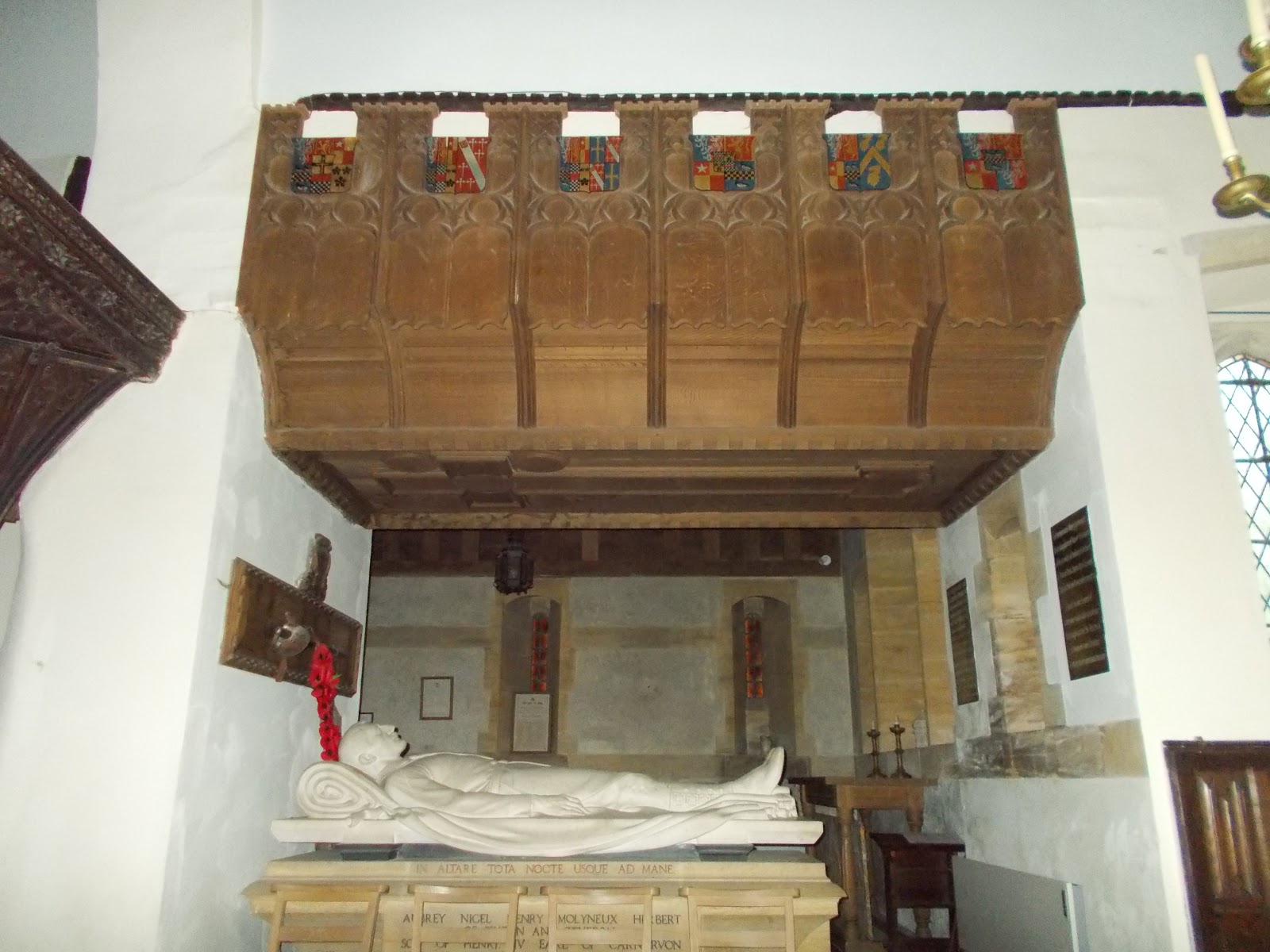
An effigy of Aubrey Herbert was made by Cecil de Banqueire (or de Blaquiere) Howard, an American sculptor who worked in Paris.  It is located at the south side of the Herbert Memorial Chapel.  It is hollow inside.

Cross window in the Herbert Memorial Chapel

Effigy of Aubrey Herbert in St Nicholas's Church, with a ceremonial sword above his head

Effigy of Aubrey Herbert

Effigy of Aubrey Herbert

Wooden canopy over Aubrey Herbert's effigy 
- this was also designed by Sir Edwin Lutyens

St Nicholas's Church, Brushford

12th century parish chest hollowed out of a single piece of oak.  It is now located in the corner of the Herbert Memorial Chapel. King Henry II (1154-1189) decreed that every parish should have a chest to collect contributions to pay for the Crusades.  These chests were later used for keeping books, documents and vestments safe.

Exterior of the Herbert Memorial Chapel

East end of the exterior of the Herbert Memorial Chapel showing the cross window

Tuesday, 15 October 2019

Catholic Church of St Stanislaus, Dulverton

The exterior of St Stanislaus's Catholic Church in Dulverton is plain and rather austere but the inside is the opposite, with lots of small but beautiful stained glass windows. 

Mrs Mary Herbert (1889-1970) of Pixton Park established a chapel in the former laundry (a corrugated iron hut) at Pixton Park during the Second World War. It was served by visiting priests until 1944 when a full time priest (Father James O'Brien) was appointed. During the war it was used by many evacuees and refugees, as well as local Catholics and the Herbert family.

Mrs Herbert knew the architect Professor Albert Richardson and asked him to design a new church, which he did in 1946. The church was never built, but in 1954 an old stable just off the High Street in Dulverton came up for sale.  Mrs Herbert asked Albert Richardson to convert it into a church.  Most of the wood for the new church was sourced locally and processed in the sawmill on the Pixton estate by Father Whelan and local volunteers. The church opened in 1955. Many of the furnishings, including the altar and a crucifix by Eric Gill came from the chapel at Pixton Park.

The church is dedicated to St Stanislaus of Krakow.  It is thought to be the only parish church in England to be dedicated to him.  The reason for the dedication is that Mrs Herbert's son Auberon had fought with the Polish forces during the Second World War and been involved with the resettlement of Polish servicemen after the war.

Stanislaus was born at Szczepanów near Krakow in 1030.  He studied in Poland and possibly also in Paris and was ordained as a priest.  He was elected Bishop of Krakow in 1072. He spoke out against the cruel, violent and unjust acts of King BoleslausIn 1079 he was accused of treason, tried and sentenced to be executed.  He was killed by King Boleslaus himself and the king then fled to Hungary.  Stanislaus was canonised by Pope Innocent IV in 1253 and later became patron saint of Poland.  His feast day is 11th April.

The 4 windows on the south side of the church depict the symbols of the authors of the four gospels: Matthew, Mark, Luke and John.  The windows were made by Silas Wood of Birmingham. The 2 rose windows were made at Buckfast Abbey in Devon. Three stained glass windows on the north wall were made by Chinks Grylls of Cannington.  They feature St Stanislaus, the gifts of the Holy Spirit and the Virgin Mary.  The Virgin Mary window is a memorial to Margaret FitzHerbert and incorporates a panel by Evie Hone.

A Portuguese dossal is hanging behind the altar.  On one side of the altar there is a 16th or 17th century Hungarian statue of St Stanislaus and on the other side is a statue of St George, which was made by Septimus Waugh.  In 1937 the author Evelyn Waugh married Laura Herbert, one of the daughters of Mr & Mrs Aubrey Herbert of Pixton Park.  (Michael) Septimus Waugh was one of their sons. There are two painting by Richard Rothwell from Morebath in Devon.  One depicts Jesus's entry into Jerusalem and the other the baptism of Jesus.

In 2019 St Stanislaus's Church in Dulverton and the adjacent residential centre were under the threat of closure.

Exterior of St Stanislaus's Church

Interior of the Church of Saint Stanislaus, Dulverton

Stained glass window of St Stanislaus

The eagle of St John
May Elizabeth Elston's memorial window
The quotation is from John Chapter 1, verse 1

The bull of St Luke
The quotation is from Luke Chapter 4, Verses 17-18

The lion of St Mark
The quotation is from Malachi Chapter 3, Verse 1

The Virgin Mary
Margaret FitzHerbert's Memorial Window (1942-1986)


Rose window above the entrance to the church

Rose window above the altar


Friday, 4 October 2019

Beard’s Stone, Banwell Hill

In 1842 a skeleton was discovered close to Bishop’s Cottage at Banwell Caves.  A local amateur archaeologist called William Beard had the bones reburied at the eastern end of Banwell Hill.  He had a large stone placed at the spot with the following poem inscribed on it:

Beard with his kindness brought me to this spot 
As one unknown and long forgot 
He made my grave and buried me here 
When there was no kind friend to shed a tear 
My bones are here, my spirit is fled 
And for years unknown numbered with the dead 
Reader as I am so shall you be 
Prepare for death and follow me.”

The stone is located on a public footpath at grid reference ST 394 587.

William Beard was born in 1772 at Woolvershill, Banwell.  His father was a farmer and he too became one.  He purchased a small farm at Wints Hill, Banwell.  A cave had been discovered by accident by some ochre miners on the west side of Banwell Hill c1757.  In 1824 Francis Randolph, Vicar of Banwell from 1808 until his death in 1831, took the initiative in exploring the same cave.  This became known as the Stalactite Cave.  He hoped to attract fee paying visitors and thus to raise funds for the local school.  

During an unsuccessful attempt to create a more convenient entrance to the cave, a second cave was discovered.  This cave contained a large number of animal bones and became known as the Bone Cave.  The bones were identified as belonging to bear, bison, reindeer, and wolf.  The Banwell caves were located on land which was owned by the Lord of the Manor of Banwell, who was also the Bishop of Bath and Wells.  The Bishop of Bath and Wells at this time was George Henry Law.  He believed that the bones were the remains of animals that had drowned during Noah’s flood.

William Beard began giving guided tours around the caves and collected donations for the school on behalf of George Law.  He renamed his house Bone Cottage.  He let out his land and concentrated on the guided tours and on exploring and collecting bones and other items from caves at Hutton, Bleadon, Sandford and Uphill with other local enthusiasts.  Bishop Law nicknamed him “Professor” and this nickname remained with him until the end of his life.  He continued to give guided tours at Banwell Caves until shortly before his death in 1868 at the age of 95.  His collection of bones was bought by the Somerset Archaeological and Natural History Society.

Inscription on Beard's Stone

Beard's Stone, Banwell Hill

Beard's Stone, Banwell Hill

Beard's Stone, Banwell Hill

Monday, 16 September 2019

Swing Bridge, Bow Street, Langport

Outside the former Railway Hotel on the west side of the River Parrett in Bow Street, Langport Westover, there is a very unusual iron swing footbridge.  

Until 1853, when the railway line from Durston to Yeovil via Langport was built, the turnpike road through Langport went past the door of the hotel, which was a pub at this time.  However the level of the turnpike road (now the A378) had to be raised so that it could cross over the railway line, which ran in a NNW-SSE direction.  The road was slightly re-aligned and embanked from the west end of Bow Bridge and a vertical stone retaining wall was built on the northern side of the embankment. The original turnpike road then became an access road to warehouses on the west side of the pub.  

The Railway Hotel was built in 1906 on the site of an earlier pub, which had burnt down.  It was decided to have the main door on the first floor, which was roughly level with the pavement of the raised main road.  However a fixed bridge would have been too low for vehicles using the access road to pass underneath it and there wasn't enough space for a conventional swing bridge.  A swing bridge comprised of two sections, which swing and close together like scissors, was the solution.  The bridge was opened and closed using a hand crank.  It is no longer in use.  The hotel was converted into six flats in the late 1980s.


Swing bridge, Bow Street, Langport

Swing bridge mechanism

Door on the first floor of the former Railway Hotel, Langport