Thursday, 14 February 2019

Zulu the Donkey, Stoke Pero Church

Stoke Pero Church stands at an altitude of 310 metres above sea level and is the highest church on Exmoor.  The church was built in the 13th century on the site of an older church, but it was extensively rebuilt and restored 1897-98.  The only original features are the tower and the porch.  Unusually the church is not dedicated to a particular saint.

The restoration was paid for by Sir Thomas Acland (12th Baronet), the owner of the nearby Holnicote Estate.  Zulu the Donkey carried all the timber used to rebuild the roof up from Porlock twice a day.  His efforts are commemorated by a portrait drawn by Hope Bourne, which hangs on the wall in the church.  Hope Bourne was a writer and painter who lived a simple and mainly self-sufficient life at various locations on Exmoor.  She died in 2010 aged 91.

Stoke Pero church was restored again in 1955.

Hope Bourne's portrait of Zulu the donkey

Zulu the donkey
 
Stoke Pero Church

Nave and chancel of Stoke Pero Church
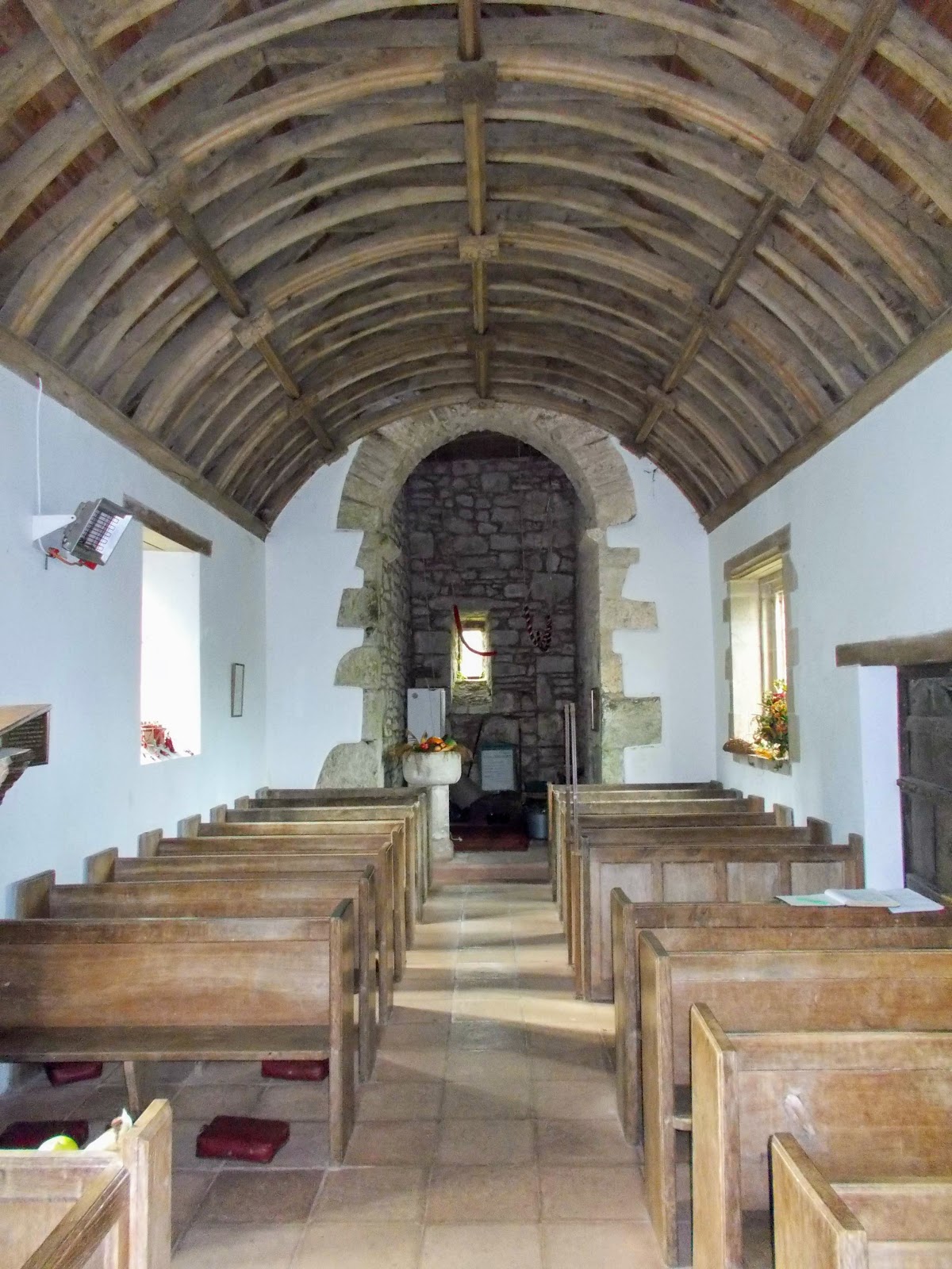
 
The Nave of Stoke Pero Church
 
Font decorated for harvest festival

Friday, 1 February 2019

Wibbly-wobbly Hedges, Montacute House

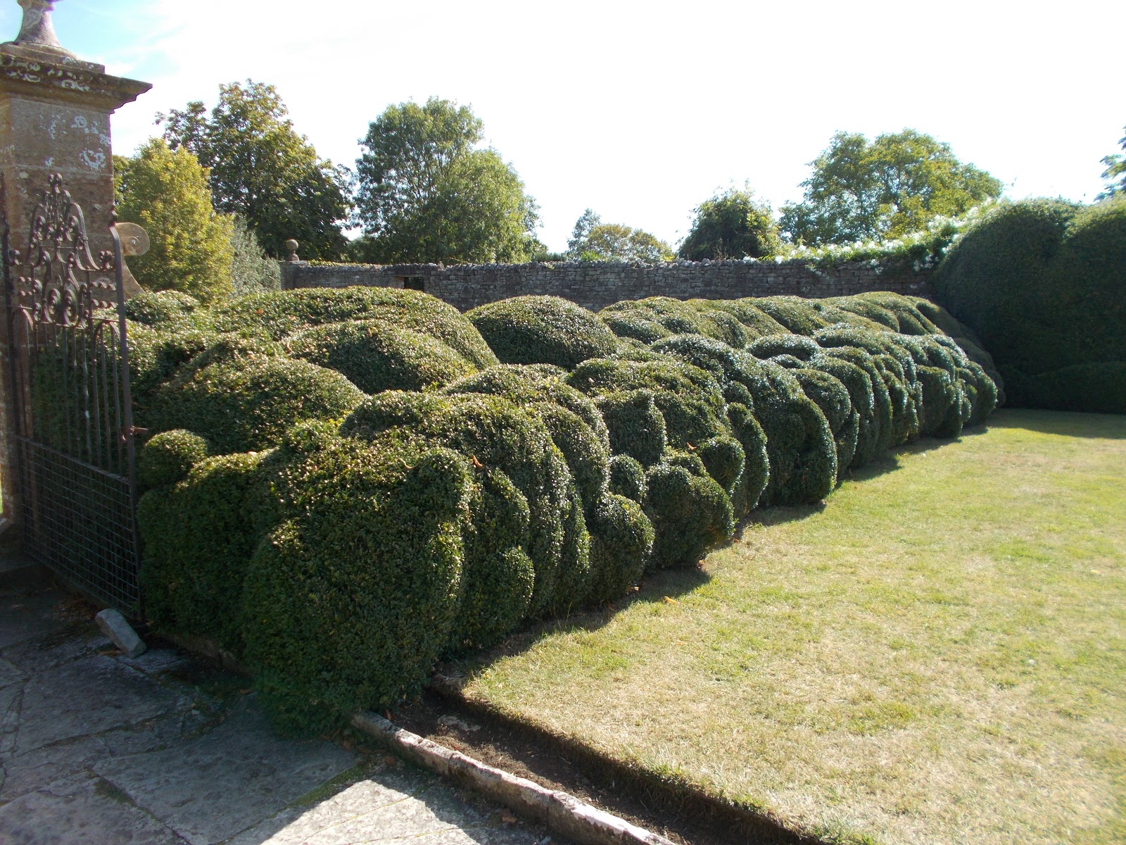
Montacute House (owned by the National Trust) has some particularly fine examples of wibbly-wobbly or "cloud" hedges.  The ones at Montacute are yew trees.  They were not originally designed to be shaped like this, but the hedges buckled under the weight of heavy snowfall in January 1947, which lasted until March.  Due to a postwar labour shortage, they weren't cut until June 1947, by which time they had become permanently misshapen.  They are now clipped to maintain the "cloud" appearance.

The National Trust's garden at Lytes Cary near Kingsdon has some smaller scale but beautifully clipped box cloud hedges.

A house facing the pebble beach at Porlock Weir has a short section of cloud hedge, although whether it is clipped this way deliberately I don't know.

Wibbly-wobbly hedge close up in the Cedar Lawn Garden

North Garden

North Garden

Wibbly-wobbly hedge undergowing repair, August 2018

Wibbly-wobbly hedge and Orangery in the North Garden

Wibbly-wobbly hedge in the Cedar Lawn Garden

Wibbly-wobbly hedge and Lord Curzon's Pavilion, Cedar Lawn Garden

Wibbly-wobbly hedge and Montacute House from the Cedar Lawn

Montacute House and wibbly-wobbly hedge from a very parched Cedar Lawn, August 2018

Cloud hedge at Porlock Weir

Cloud hedge at Lytes Cary

Cloud hedge at Lytes Cary

Monday, 14 January 2019

Smitham Chimney, East Harptree Woods

Smitham Chimney and the pond next to it are the only visible remains of a lead smelting plant.  The stone and brick chimney is located on Smitham Hill in the middle of East Harptree Woods.  A public footpath runs through the site.  The grid reference for the site is ST 554 546.

Lead mining in the Mendips dates back to at least the Iron Age and it continued in the Roman period and on into medieval times.  It reached its peak in the late 16th/early 17th centuries but by the 18th century most of the easily available lead had been mined and flooding in the shafts became an issue.  Silver, zinc, iron, ochre, manganese and calamine were also mined at various locations on the Mendip Hills. At various periods lead was mined at East Harptree; Velvet Bottom at Charterhouse; Priddy; Stockhill and Chewton Mendip.  At East Harptree lead was mined from veins in the Carboniferous Limestone and zinc and manganese were mined from veins in the Dolomitic Conglomerate.

In 1867 a group of Cornish miners formed the East Harptree Lead Works Company, in order to re-smelt the heaps of slag and slimes left by previous mining ventures.  New techniques developed in Cornwall meant that they could now release lead that earlier miners had not been able to remove from the ore. The lead produced was used for the shot in guns.  The chimney vented the smoke produced by five lead condenser flues.  These are clearly shown on an Ordnance Survey map of 1883 stretching out in a north easterly direction from the chimney.  They have subsequently been planted over with conifers and are now barely visible.  Areas of what is known in the Mendips as "gruffy ground" (uneven pockmarked mined ground) can apparently be seen in the woods.  The pond was originally a reservoir for the lead smelting works.

The site at East Harptree closed in 1875 and all the buildings except the 70 feet high chimney were later demolished.  The chimney was renovated in 1914 and again in the 1973 by the Mendip Society and Somerset County Council. 

A brickworks is shown on the 25" Ordnance Survey map of 1883 on the eastern side of the lead works.  However it was already disused by this time.

Maybe it is an optical illusion but the top of the chimney looks like it is leaning to the left?

Doorway at the bottom of the chimney:
it looks like lots of birds nest inside, judging by the huge pile of sticks behind the grill!

Smitham Chimney

Smitham Chimney and pond

Reflection of Smitham Chimney in the pond

Smitham Chimney and Pond

Pond

Tuesday, 1 January 2019

Thomas Coryate's Shoes, Odcombe Church

Thomas Coryat(e) was born in the village of Odcombe in around 1577.  His father George was the rector of Odcombe.  Thomas went to school in Winchester.  He then went to Oxford University for three years, where he studied Greek and Latin, but he left without a degree.  He wanted to see the world and become famous.  He joined the household of Henry, Prince of Wales, thanks to his acquaintance with the Phelips family of Montacute.  He was the unofficial court jester.

In May 1608 Thomas sailed from Dover to Calais and travelled on to Paris.  He was befriended by members of King Henri IV's household.  He then travelled on to Lyon, Savoy, Turin, Milan, Mantua, Padua and Venice.  He walked some of the way, carrying only a staff and a knife for protection, but he also travelled by boat, horseback, coach and cart.  He arrived in Venice on 24th June 1608 and stayed in the city for 6 weeks.  He then returned to England via Padua, Vincenza, Verona, Bergamo, Zurich, Basel, Strasbourg, Heidelberg, Mainz, Cologne, Middelburg and Flushing.  He was threatened with violence by a German peasant in the Black Forest when he was caught picking grapes in a vineyard.   He sailed from Flushing (Vlissingen) in the Netherlands to London and arrived there on 3rd October 1608, having travelled approximately 1,975 miles. 

On his return to Odcombe Thomas Coryat hung his shoes up in the parish church.  They remained there until the early 18th century.  They were lost at some point after this and today there is a stone replica of the shoes hanging on the wall in the church of St Peter and St Paul.

Table forks were widely used in Italy at this time, but not in England.  Thomas acquired one, which he brought back to England and he is credited with introducing forks to this country. 

Thomas Coryate wrote a book about his experiences called Coryats Crudities.  Thomas asked well known people to write commendatory or panegyric verses to preface his book.  About 60 people supplied contributions, some of which mocked or insulted Thomas.  The book was published in 1611.  It was possibly the first ever guidebook for travellers to Europe.  The book contained illustrations; statistics; architectural descriptions; information about local customs, prices, exchange rates, food and drink.  In the book he described how the Italians shielded themselves from the sun and he was the first person to use the word "umbrella" in English literature.

On 20th October 1612 Thomas set off again on his travels. He sailed to Constantinople (now Istanbul), in Turkey where he stayed for 10 months and learnt Turkish and Italian.  In January 1614 he sailed to Iskenderun in Turkey and then travelled on to Aleppo (Syria).  In March 1614 he walked with a caravan of Christian pilgrims to Jerusalem via Damascus.  He then visited Nazareth, Bethlehem, Jericho and the River Jordan before walking back to Aleppo.  He stayed there for 4 months writing up his notes, which he sent back to England.  These were eventually published in 1625 by Thomas Purchas in his Purchas his Pilgrimes.

Thomas Coryate, who was known as the Odcombian Legstretcher, then decided to walk to India, to prove he was the greatest walker in the world.  He joined a caravan of people and walked to Isfahan (Iran) via Diyarbakir (Turkey), Tabriz (Iran) and Qazvin (Iran).  After 2 months in Isfahan he joined another caravan and walked to Ajmer in India via Kandahar (Afghanistan), Multan (Pakistan), Lahore (Pakistan), Delhi and Agra. He arrived in Ajmer in July 1615, having walked a total of about 3,300 miles from Aleppo to Ajmer.  He stayed in Ajmer for 14 months where he learnt Persian and Hindustani and continued to study Turkish and Arabic.  In September 1616 Thomas left Ajmer and visited Kangra and Hardwar before returning to Agra in July 1617.  He then travelled 400 miles to visit the ruined city of Mandu. 

In November 1617 Thomas set off for Surat.  He died of dysentery at Surat in Gujarat in December 1617.

Thomas Coryate said Odcombe, was famous for five things:

 "its wholesome and pleasant air; its wool; its Church 'being erected upon so loftie a place that it overprieth and overtoppeth the whole countrie round about', its sweet springs of water, and finally and most important, the love and unity of its inhabitants, 'for we all from the verie highest to the lowest are most firmly knit together in an indissoluble knot of friendship."

Replica of Thomas Coryate's shoes in Odcombe Church

Am I the only one who thinks the shoes look like flatbreads decorated with cheese and tomatoes?

Thomas Coryate's thoughts about Odcombe

Piece of brick from Thomas Coryate's grave in Surat, India

Dom Moraes' memorial in Odcombe Churchyard

Dom Moraes (19th July 1938 – 2nd June 2004) was an Indian writer and poet.  He wrote in English and published a number of books.  He was fascinated by Thomas Coryate's life and visited Odcombe on several occasions.  In 2003 he and his partner Sarayu Srivatsa visited Odcombe to promote their book about Thomas Coryate - The Long Strider: How Thomas Coryate Walked from England to India in the Year 1613.  He brought with him a piece of brick from Thomas Coryate's grave and this is now mounted on a shelf in Odcombe Church, next to the replica shoes.

After Dom's death in 2004, Sarayu brought some earth from his grave in India and scattered it in Odcombe Churchyard.  He also installed a memorial stone to Dom in the churchyard close to the main entrance to the church.

St Peter and St Paul's Church, Odcombe

St Peter and St Paul's Church, Odcombe

Friday, 14 December 2018

Three Shire Stones, Batheaston

The Three Shire Stones are located at the tripoint where the counties of Somerset, Gloucestershire and Wiltshire meet. In the case of Somerset, it is the historic county, rather than the modern one, as the stones are now located in the parish of Batheaston, Bath & North East Somerset.  In the case of Gloucestershire it is also the historic county, as the stones are currently located in South Gloucestershire (Marshfield parish).  The grid reference is ST 796 701.

There are three large upright stones with a horizontal capstone on top of them, arranged to look like a prehistoric megalith.  However they were apparently only erected in 1859, incorporating three smaller stones, which were erected in 1736.

The Three Shire Stones are easy to miss, as although they are on the side of an unclassified road (the Fosse Way), they are partially hidden by a stone wall immediately to the north and by trees to the south.  There is nowhere to park at the stones and they are on a surprisingly busy straight road and most of the cars drive by at speed.  There is a field gateway about 120 metres to the south and on the same side of the road as the Three Shire Stones (the west side).  It is possible to walk north along the grass verge from the parking place to get to the stones.

There are (or once were) other Three Shire Stones in England e.g. where Cumberland, Lancashire and Westmorland once met.  There are (or used to be) also Three Shire Oaks e.g. where Nottinghamshire, Leicestershire and Lincolnshire meet.

Three Shire Stones - view from the road

Three Shire Stones

Three Shire Stones - looking east towards the road

Saturday, 1 December 2018

Burgundy Chapel, North Hill

The ruined Burgundy Chapel is located on the north side of North Hill, two miles north-west of Minehead and close to the coast but about 80 metres above sea level.  It is sited on the western side of the stream, which runs down Burgundy Chapel Combe.  

Burgundy Chapel dates back to the medieval period but was never very large: 25 feet long by 16 feet wide.  It was mentioned in the Luttrell's (of Dunster Castle) household accounts for 1405 as "Bircombe Chapel", so it was presumably built by them.  It may have been built as a thanksgiving for a family member returning safely from fighting in Burgundy, in what is now France, during the Hundred Years' War (1337-1453).

The chapel was ruined by 1717 and only a couple of walls and a doorway remain standing today.  The site was excavated in the 1940s and again in 1985, when some consolidation work was carried out to the ruins.  The site gets very overgrown during the summer months.


Burgundy Chapel

Burgundy Chapel

Doorway

Doorway

Mini-shrine, 2020

Thursday, 15 November 2018

Winter's Tower or Combe Wood Lodge/Tower, Combe Florey

Winter's Tower or Combe Wood Lodge/Tower, as it is also known, was built in around 1750 for local landowner John Winter.  He lived at Watts House on the western edge of Bishops Lydeard.  This house is now Cedar Falls Health Farm and Spa.  His reasons for building the tower were to provide an "eyecatcher" to be seen from Watts House, to provide accommodation for his gamekeeper and also to enable him to spy on his neighbours, the Lethbridges of Sandhill Park, with whom he did not get along.

The tower, which is five storeys high, was constructed from the local sandstone and then rendered.  It was lived in until the early 20th century but was derelict by the 1930s.  It was restored in 1991 by a specialist builder from Burnham-on-Sea called Des Baker.  He re-rendered the walls and installed modern conveniences.  It was restored again in 2006 and the render was replaced with a breathable traditional lime based render. 

Combe Wood Tower
My thanks to Stan for allowing me to use his photograph.

Thursday, 1 November 2018

St Michael's Tower, Montacute

St Michael's Tower is a prospect tower or folly located on the top of St Michael's Hill (139 metres above sea level), which is located to the west of the village of Montacute.  It is 15 metres high and there is a 52 step spiral staircase inside it.  It currently has no door and you can climb to the top of the tower but not out onto the roof.

In Saxon times a miraculous black flint Holy Cross was discovered on the hill and taken to Waltham in Essex, where it performed miracles and a church was built to house it (Waltham Abbey). It is now lost.

A Norman called Robert, Count of Mortain, built a castle on top of the hill by 1086.  Robert was the half-brother of William the Conqueror. It was one of only two Somerset castles mentioned in the Domesday Book (the other was Dunster) and it may have been built of stone. The Normans named the hill Mons Acutus (meaning steep hill) and the village of Montacute is named after it. 

In 1086 the castle was briefly and unsuccessfully besieged by the English, who were upset that the castle had been constructed on the site where the holy cross had been found.

In around 1102 a monastery was built at the bottom of the hill and on its eastern side by William, Count of Mortain (Robert's son).  The castle was demolished and a chapel was built on the top of the hill.  Stone from the castle was possibly used to build the monastery.  The chapel on the hill was dedicated to St Michael the Archangel.  Churches and chapels on top of hills are often dedicated to him. 

The Phelip's family purchased the monastery from the Crown after the Dissolution of the Monasteries in the 1530s and built Montacute House using some of the stone from the monastery.  The chapel survived until c1630.  In 1760 Edward Phelips built an eyecatcher or prospect tower on top of the St Michael's Hill using the local golden coloured Ham stone. There is a Green inscription over the door, the initials KP and the date 1760.

St Michael's Tower is now owned by the National Trust, which acquired Montacute House in 1931.

St Michael's Tower

St Michael's Tower

St Michael's Tower

Looking down from the top of the spiral staircase

Fireplace at the top of the tower

View from the top of the tower

Graffiti at the top of the tower - artistic in its own way

St Michael's Tower, May 2023

Greek inscription over the doorway