Local Justices of the Peace were given the powers by Parliament to erect toll gates on part of the Great North Road (now the A1) in 1663. Twelve more Justice Trusts were set up between 1696 and 1714 on sections of road, which were particularly badly maintained. Local groups of wealthy people paid for improved roads to be built and then charged people tolls for using them.
The first turnpike trusts were set up in 1707 and were run by trustees, who were local Justices, gentlemen and landowners. The trusts were non-profit making, but their funds were not subject to audit and there was no legal requirement to keep any roads in a good state of repair. They were given powers to set and levy tolls on the users of specified stretches of road, usually about 20 miles in length.
133 turnpike trusts were set up by Acts of Parliament before 1750. Between 1751 and 1772 another 418 acts were passed and the turnpike network expanded across the whole of England, although only about a fifth of Britain's roads were turnpikes. The last act was passed in 1836, by which time the railway network was beginning to be developed. Turnpikes were used by stage coaches from the 1750s, where the road conditions were good enough.
The turnpike road network reached its greatest extent in the 1830s when there were over 20,000 miles of roads controlled by over 1,000 trusts in England and Wales. Traffic on the turnpike roads declined from the 1840s as the railway network developed.


 Toll house at Horton Cross near Ilminster
 Toll house on Station Road, Ilminster


 Turnpike Cottage, Crimchard
The 1st turnpike trust in Somerset was the Bath Trust in 1707, then Bristol in 1727 and Bridgwater in 1730. Most of Somerset's turnpike trusts were set up between 1752 and 1759. The network of turnpike roads in Somerset was initially the existing main and secondary roads, which were widened and improved. A few new roads were built later.
Turnpikes trusts erected gates across their roads at strategic locations to collect tolls from the people who used them. Early turnpikes had wooden gates but those built in the 19th century often had gates made of wrought iron. The gates were often at points where it was least likely that horse riders or horse drawn vehicles could avoid paying the toll e.g. bridges and crossroads. They were usually located outside urban areas to avoid charging local businesses.
The word turnpike was originally a military term for "a spiked barrier fixed in or across a road or passage, as a defence against sudden attack, especially of men on horseback." (Oxford English Dictionary). The bars erected on toll roads resembled these barriers and so they were referred to as turnpikes from the late 17th century.
In some cases existing cottages were adapted to house toll collectors (or pikemen as they were sometimes known) and their families. Sometimes temporary shelters were built for the toll collectors. Later on most toll houses were purpose built. Early toll houses were built in the same style as local cottages in the area but by the 19th century a distinctive style evolved. Many toll houses resembled the lodges built at the entrance to large estates and those built in the 1820s had polygonal fronts, which gave the toll collectors good views up and down the roads. Toll houses were usually built close to the road and many of them had porches, which jutted out into the road. On major roads grander toll houses were built e.g. with castellations on them to impress wealthy travellers. The isolated location of most toll houses meant that they were vulnerable to attack by thieves and highwaymen. Therefore the windows often had shutters and/or bars on them and the houses also had built-in safes. Toll houses were often built to a higher standard that most of the local vernacular cottages, in order to attract honest and reliable toll collectors.
The word turnpike was originally a military term for "a spiked barrier fixed in or across a road or passage, as a defence against sudden attack, especially of men on horseback." (Oxford English Dictionary). The bars erected on toll roads resembled these barriers and so they were referred to as turnpikes from the late 17th century.
In some cases existing cottages were adapted to house toll collectors (or pikemen as they were sometimes known) and their families. Sometimes temporary shelters were built for the toll collectors. Later on most toll houses were purpose built. Early toll houses were built in the same style as local cottages in the area but by the 19th century a distinctive style evolved. Many toll houses resembled the lodges built at the entrance to large estates and those built in the 1820s had polygonal fronts, which gave the toll collectors good views up and down the roads. Toll houses were usually built close to the road and many of them had porches, which jutted out into the road. On major roads grander toll houses were built e.g. with castellations on them to impress wealthy travellers. The isolated location of most toll houses meant that they were vulnerable to attack by thieves and highwaymen. Therefore the windows often had shutters and/or bars on them and the houses also had built-in safes. Toll houses were often built to a higher standard that most of the local vernacular cottages, in order to attract honest and reliable toll collectors.
In the early 19th century there were two different methods of road construction in general use, which had been developed by Thomas Telford (1757-1834) and John Loudon McAdam (1756-1836). Telford's method with 9" long stones packed together on end, with smaller stones rammed into the top and a layer of small stones on the top, was very effective, but also expensive.
McAdam's method was cheaper: stone was broken into pieces weighing less than 6 ounces. This was then spread in layers to a depth of 10". This method re-used material recovered from earlier surfaces. The surface was not rolled - it was gradually compacted by passing traffic.
John Loudon McAdam became the General Surveyor to the Bristol Turnpike Trust in December 1815. He worked for the Bristol Trust with his son, who was also called John Loudon McAdam, until his death in 1836. In 1826 he also became General Surveyor for the Bath Trust. He worked for the Bath Trust with his grandson William until 1836.
The turnpike road network reached its greatest extent in the 1830s when there were over 20,000 miles of roads controlled by over 1,000 trusts in England and Wales. Traffic on the turnpike roads declined from the 1840s as the railway network developed.
Most turnpike trusts were wound up in the 1870s and the toll houses were sold off. Some became commercial buildings such as pubs and post offices but most became residential dwellings. The last turnpike trust to be wound up was one on Anglesey in 1895.
Responsibility for roads was taken over by Highway Districts from 1862. Highway Districts were abolished in 1894 and their duties and powers passed to Rural District Councils. Responsibility for main roads passed to the newly formed County Councils in 1889.
Roads continued to be built and maintained using the Telford and McAdam methods until the early 20th century. Main roads in Somerset were surface dressed with tar from 1908, but it wasn't until the 1920s that they were constructed using several inches of stone, which had been pre-coated in tar or bitumen.

Toll House, Nether Stowey

Toll House, Snowdon Hill, A30, Chard

Horsington Toll House

Horsington Toll Board

Stanton Drew Toll House

Worthy Toll Road Toll House, Porlock Weir - still in use as a toll house

Toll House, Glaston Road, Street
You can see where the original doorway facing the road has been blocked up at some point.

Toll House, Glaston Road, Street

Toll House at Shipham

Red Post Toll House on the A367 at Peasedown St John

This house on Silver Street in Taunton was probably once a toll house

Exebridge Toll House on A396 at the Devon/Somerset border

Toll Cottage, Tower Hill, A358, Williton

Sidcot Gate Toll House on the A38 at Sidcot

Blue plaque on the Sidcot Gate Toll House

Old Down Toll House
This was built in 1835 and is located on the B3139 (Lynch Hill), opposite the junction with Coalpit Lane.

Hartlake Turnpike plaque at the junction of the A39 with Chasey's Drove, to the north of Glastonbury. This was part of the Wells Turnpike Trust.

Terminus stone on the Brendon Hills at Elworthy, marking the western boundary of the Taunton Turnpike Trust
The Taunton Turnpike Trust was in operation from 1752 until 1875.

Part of the toll board from Misterton Gate
This is now on display in the Museum of Somerset in Taunton.

East Cranmore Toll House on the A361

Charlton Toll House on the A361 at Shepton Mallet

Toll Cottage, on the corner of Ford Road (B3188) and Taunton Road (B3227) in Wiveliscombe

Toll house, 48 Chilkwell Street, Glastonbury

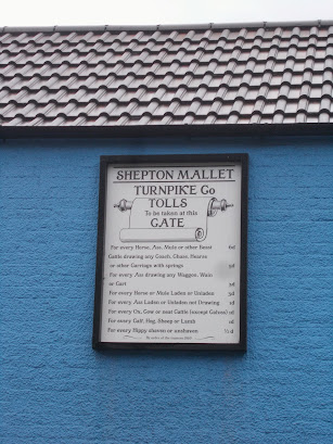
Modern toll board on the toll house, 48 Chilkwell Street, Glastonbury


Turnpike House, Westhay
This toll house was on the Wedmore Turnpike Trust's road across the Somerset levels to Rowberrow. It is on the corner of Main Road (B3151) and Westhay Moor Drove. The blank wall facing the road is where the original doorway would have been located.

Toll house, Kingbury Epsicopi
This toll house, which is located on Thorney Road, was built in the early 19th century for the Langport, Somerton and Castle Cary Turnpike Trust.

Further Reading:
The Toll-houses of Somerset by Jane Dowding and Patrick Taylor. Published by Polystar Press, 2013
Somerset Roads: The Legacy of the Turnpikes, Phase 1 Western Somerset by J.B. Bentley and B.J. Murless. Published by Somerset Industrial Archaeological Society, 1985


