Friday, 14 December 2018

Three Shire Stones, Batheaston

The Three Shire Stones are located at the tripoint where the counties of Somerset, Gloucestershire and Wiltshire meet. In the case of Somerset, it is the historic county, rather than the modern one, as the stones are now located in the parish of Batheaston, Bath & North East Somerset.  In the case of Gloucestershire it is also the historic county, as the stones are currently located in South Gloucestershire (Marshfield parish).  The grid reference is ST 796 701.

There are three large upright stones with a horizontal capstone on top of them, arranged to look like a prehistoric megalith.  However they were apparently only erected in 1859, incorporating three smaller stones, which were erected in 1736.

The Three Shire Stones are easy to miss, as although they are on the side of an unclassified road (the Fosse Way), they are partially hidden by a stone wall immediately to the north and by trees to the south.  There is nowhere to park at the stones and they are on a surprisingly busy straight road and most of the cars drive by at speed.  There is a field gateway about 120 metres to the south and on the same side of the road as the Three Shire Stones (the west side).  It is possible to walk north along the grass verge from the parking place to get to the stones.

There are (or once were) other Three Shire Stones in England e.g. where Cumberland, Lancashire and Westmorland once met.  There are (or used to be) also Three Shire Oaks e.g. where Nottinghamshire, Leicestershire and Lincolnshire meet.

Three Shire Stones - view from the road

Three Shire Stones

Three Shire Stones - looking east towards the road

Saturday, 1 December 2018

Burgundy Chapel, North Hill

The ruined Burgundy Chapel is located on the north side of North Hill, two miles north-west of Minehead and close to the coast but about 80 metres above sea level.  It is sited on the western side of the stream, which runs down Burgundy Chapel Combe.  

Burgundy Chapel dates back to the medieval period but was never very large: 25 feet long by 16 feet wide.  It was mentioned in the Luttrell's (of Dunster Castle) household accounts for 1405 as "Bircombe Chapel", so it was presumably built by them.  It may have been built as a thanksgiving for a family member returning safely from fighting in Burgundy, in what is now France, during the Hundred Years' War (1337-1453).

The chapel was ruined by 1717 and only a couple of walls and a doorway remain standing today.  The site was excavated in the 1940s and again in 1985, when some consolidation work was carried out to the ruins.  The site gets very overgrown during the summer months.


Burgundy Chapel

Burgundy Chapel

Doorway

Doorway

Mini-shrine, 2020

Thursday, 15 November 2018

Winter's Tower or Combe Wood Lodge/Tower, Combe Florey

Winter's Tower or Combe Wood Lodge/Tower, as it is also known, was built in around 1750 for local landowner John Winter.  He lived at Watts House on the western edge of Bishops Lydeard.  This house is now Cedar Falls Health Farm and Spa.  His reasons for building the tower were to provide an "eyecatcher" to be seen from Watts House, to provide accommodation for his gamekeeper and also to enable him to spy on his neighbours, the Lethbridges of Sandhill Park, with whom he did not get along.

The tower, which is five storeys high, was constructed from the local sandstone and then rendered.  It was lived in until the early 20th century but was derelict by the 1930s.  It was restored in 1991 by a specialist builder from Burnham-on-Sea called Des Baker.  He re-rendered the walls and installed modern conveniences.  It was restored again in 2006 and the render was replaced with a breathable traditional lime based render. 

Combe Wood Tower
My thanks to Stan for allowing me to use his photograph.

Thursday, 1 November 2018

St Michael's Tower, Montacute

St Michael's Tower is a prospect tower or folly located on the top of St Michael's Hill (139 metres above sea level), which is located to the west of the village of Montacute.  It is 15 metres high and there is a 52 step spiral staircase inside it.  It currently has no door and you can climb to the top of the tower but not out onto the roof.

In Saxon times a miraculous cross was discovered on the hill and taken to Waltham in Essex, where it performed miracles and a church was built to house it (Waltham Abbey).

A Norman called Robert, Count of Mortain built a castle on top of the hill by 1086.  Robert was the half-brother of William the Conqueror. It was one of only two Somerset castles mentioned in the Domesday Book (the other was Dunster) and it may have been built of stone. The Normans named the hill Mons Acutus (meaning steep hill) and the village of Monacute is named after it. 

In 1086 the castle was briefly and unsuccessfully besieged by the English, who were upset that the castle had been constructed on the site where the holy cross had been found.

In around 1102 a monastery was built at the bottom of the hill and on its eastern side by William, Count of Mortain (Robert's son).  The castle was demolished and a chapel was built on the top of the hill.  Stone from the castle was possibly used to build the monastery.  The chapel on the hill was dedicated to St Michael the Archangel.  Churches and chapels on top of hills are often dedicated to him. 

The Phelip's family purchased the monastery from the Crown after the Dissolution of the Monasteries in the 1530s and built Montacute House using some of the stone from the monastery.  The chapel survived until c1630.  In 1760 Edward Phelips built an eyecatcher or prospect tower on top of the St Michael's Hill using the local golden coloured Ham stone. There is a Green inscription over the door, the initials KP and the date 1760.

St Michael's Tower is now owned by the National Trust, which acquired Montacute House in 1931.

St Michael's Tower

St Michael's Tower

St Michael's Tower

Looking down from the top of the spiral staircase

Fireplace at the top of the tower

View from the top of the tower

Graffiti at the top of the tower - artistic in its own way

St Michael's Tower, May 2023

Greek inscription over the doorway

Sunday, 14 October 2018

Pinkery Pond, Exmoor

Pinkery Pond is an artificial lake, which was created c1830 by damming the headwaters of the River Barle with a massive stone and earth dam.  It is located high up on Exmoor on the south side of The Chains in the far west of Somerset, half a mile from the Devon border.  The surface area of the pond is 1.2 hectares.  The name Pinkery was probably originally either pen creagh or pen carreg, meaning "rocky outcrop".  The name is wrongly written on some maps as Pinkworthy.

A canal was dug c1819-20 to convey the water from Pinkery Pond eastwards to Little Ashcombe, before the pond itself was constructed.  However the canal was never completed, as the culverts needed to carry it across several combes were never built.  Another contour canal or leat was constructed from Great Buscombe to Swap Hill near Larkbarrow.

Pinkery Pond was created for John Knight by 200 Irish labourers.  John Knight (1767-1850) came from a family of ironmasters and agricultural innovators in the north of Herefordshire and in Worcestershire.  He purchased the former Royal Forest of Exmoor in 1818 and he later bought more of the adjoining land.  He lived at Simonsbath House in Simonsbath.  He began an ambitious land reclamation programme to convert large areas of moorland into arable land or pasture for cattle and sheep.  He also had two farms built at Honeymead and Cornham and planted beech hedges as windbreaks.  His agricultural improvement work was carried on by his son Frederic.

The original purpose of Pinkery Pond is not clear.  Possible reasons that have been suggested for Pinkery Pond's creation include:
  • To provide water irrigation for farmland downstream
  • To supply water to the canals, which could be used to transport large quantities of locally produced lime in tub boats.  This would have been used to improve the soil quality on local farms by neutralising the naturally acidic soils.
  • To provide water power for agricultural machinery
  • To provide water power for an incline at Prayway Head on a proposed railway, which would have carried iron ore from mines in the Simonsbath area down to Porlock.
  • John Knight just desired to have a boating lake on his estate
The overflow for the pond is a tunnel cut through the bedrock in the south east corner of the dam.  The water then drains into the River Barle.  The overflow may have been cut some time after pond was created, in order to reduce the size of it.  The pond currently holds 37,000 cubic metres of water but it would hold 80,000 if it was allowed to fill completely.  Despite being in an area of high rainfall it fills up slowly as its catchment area, close to the source of the River Barle, is very small.

Pinkery Pond can be drained by removing wooden plugs in two pipes in the dam wall.  It has apparently been drained on at least two occasions: in 1889 to recover the body of Richard Gammin, a farmer from nearby Parracombe and in 1912 in the unsuccessful search for another suspected suicide: Willam Stenner.  William Stenner had killed himself but his body was eventually found in a mineshaft.  Engineers had to push the plugs out using hydraulic jacks and retreat quickly before the water started to flood out.

Pinkery Pond is often shrouded in low cloud, as it is located 440 metres above sea level.  I have visited it four times and on two of those occasions it was too misty to see across it.  My thanks to Stan for taking the following photos for me on a clear day and for allowing me to use them.

Pinkery Pond

Pinkery Pond

Looking west across the dam

Overflow tunnel on the Pinkery Pond side

Overflow tunnel exit

The River Barle below Pinkery Pond

Monday, 1 October 2018

St Andrew's Chapel, Luccombe

The remains of a small chapel can be seen at the appropriately named Chapel Cross on a minor road between Luccombe and Horner (but closer to Luccombe).  Not much is known about the history of the chapel but it is thought to date from the medieval period (possibly the 14th century) and to have been dedicated to St Andrew.  At some point after this time most of the stones were removed to be used in buildings elsewhere.  The site was excavated in around 1897 by the Reverend F. Hancock.  Today the remaining walls are only a foot or so high.  In the spring the site is carpeted with celandines and primroses.

Primroses and Celandines in flower April 2018
 
St Andrew's Chapel, looking west
 
St Andrew's Chapel, looking east
 
More primroses and celandines and a small piece of wall
 
St Andrew's Chapel remains
 - showing where the doorway at the west end of the south wall was once located

Monday, 17 September 2018

Death of the Staghound Recorder, Horner Wood

There is a small memorial in Horner Wood to a "Staghound Recorder" who was "killed here September 10th 1882".   I have searched the West Somerset Free Press for that period using the British Newspaper Archive but was not able to find any record of this event or the name of the person who was killed.  Update May 2020 - I have been informed that the memorial is to a dog - a staghound called Recorder - not a person.

Staghound Recorder Memorial

Saturday, 1 September 2018

Tin Tabernacles

As the population of Britain grew during the 19th century, the Church of England, Roman Catholic Church and non-conformist denominations needed new affordable churches, which could be erected quickly.  A series of religious revivals during the 19th and early 20th century also led to an increase in the number of people attending churches.

Folding a sheet of iron gives it stiffness and rigidity.  In the 1820s Henry Palmer, an engineer from London, developed a new method of corrugating iron.   Richard Walker realised that Palmer's corrugated iron could be used for cladding buildings such as warehouses.  Then in 1837 hot dip galvanising was invented by a French engineer called Stanislaus Sorel.  Galvanising is the process by which iron is coated with a thin layer of zinc, thus preventing it from corroding and greatly increasing its life span.  Tin was never used for coating corrugated iron for buildings. 

Large scale production of prefabricated corrugated iron buildings began in the 1850s.    Churches, chapels and mission halls were designed and built in flat pack kit form and sold via catalogues.  These churches were nicknamed tin tabernacles.  A tabernacle is "a temporary dwelling; generally movable, constructed of branches, boards, or canvas; a hut, tent, booth" (Oxford English Dictionary).  Most tin tabernacles were intended to provide short term accommodation for church congregations while they raised money to build a more permanent church.  However many were never replaced by more durable structures.

Tin tabernacles were built on a brick or rubble and mortar foundation.  They were timber framed and clad on the outside with galvanised corrugated iron.  Corrugated iron sheets were rigid and light enough to span between roof beams unsupported.  The sheets could be overlapped to form an interlocking and watertight roof.

The inside walls were usually lined with wooden tongue and groove boards.  The flooring was either beaten earth, flagstones or suspended wooden floorboards.  The buildings were insulated with felt placed between the inner and outer walls. The windows were sometimes rectangular but many churches had Gothic arch windows.  Some had small steeples or bell towers on their roofs.  Lighting was usually provided by paraffin lamps.  In urban areas this was later replaced by gas lighting.  Small coal or wood burning stoves were sometimes installed to heat the buildings.

Prefabricated corrugated iron buildings were made by several different British companies in cities such as London, Liverpool, Manchester, Edinburgh, Glasgow and Norwich (Boulton and Paul).  In addition to churches, they also made a variety of other types of buildings e.g. houses, village halls, synagogues, school rooms, temperance halls, hotels, bunkhouses, sports pavilions, hospital wards and warehouses.  Many were exported to Canada, Australia, California and Africa, especially during their gold rush periods.  The peak period for the production of corrugated iron buildings was probably the 1890s.

Most tin tabernacles were eventually demolished or are now derelict.   A few have been converted to other secular uses but some are still in use as churches.  In Somerset tin tabernacle churches are still in use at Edithmead, Langley Marsh, Porlock Weir and Alhampton near Ditcheat. The tin tabernacles at Monksilver and Rodhuish are currently derelict and very overgrown.   Stapley's tin tabernacle looks to be in good condition, but it isn't in use as a church. The tin tabernacle on the A38 at Barrow Common in North Somerset is in good condition, but when I visited in April 2018 it didn't look like it was in use as a church.

Further Reading:

Ian Smith: Tin Tabernacles: Corrugated Iron Mission Halls, Churches & Chapels of Britain, published by Camrose Media in 2004

St Andrew's Mission Church, Edithmead

St Nicholas' Church, Porlock Weir
This church was built c1880

Inside St Nicholas' Church, Porlock Weir

Stained glass east window in St Nicholas' Church, Porlock Weir


St Luke's Church, Langley Marsh

Disused Wesleyan Methodist Chapel, Monksilver

Manufacturer's name plate on the Monksilver Methodist Chapel
It was made by William Harbrow of South Bermondsey Station, London

Barrow Common - former Baptist Church

Barrow Common's tin tabernacle

Alhampton Chapel

Alhampton Chapel

Inside Alhampton Chapel

Not much is known about the history of Alhampton Chapel.  The land it stands on was given to the church in 1887 and it was built in 1892, probably by Boulton and Paul.  It is a "daughter" church of St Mary Magdalene in Ditcheat.  By 2000 the condition of the chapel had deteriorated to such an extent that it was in danger of having to be closed.  The churchwarden raised £25,000 to fund its restoration, which was finally completed by 2011.

Bible Christian Chapel, Felon's Oak Lane, Rodhuish

Bible Christian Chapel, Rodhuish

The Bible Christian Chapel in Felon's Oak Lane in Rodhuish was built in 1898.  It was part of the Kingsbrompton Methodist Circuit and in 1959 it had 15 members and two services were held there every Sunday.  For most of the 20th century the majority of the congregation were boarders from the girls' school at Croydon Hall.  The chapel closed in 1973 and when I visited in October 2018 it was barely visible behind a forest of brambles and other plants.  It was just about possible to make out the gate and the porch through the undergrowth.

Stapley Tin Tabernacle

Stapley Tin Tabernacle

Stapley Tin Tabernacle, February 2024

Tuesday, 14 August 2018

Swildon's Hole, Priddy

Swildon's Hole is the longest cave on the Mendips, both in terms of total passage length (c.9,144 metres) and the distance from the entrance to the farthest point reached (Sump 12 at c.2,400 metres).  Its alternative name is St Swithin's Hole and the word Swildon may be a corruption of Swithun, who was Bishop of Winchester from 853 until his death in 862 or 865.  Land in the Priddy area was once owned by the Priory of Winchester.  Swildon's Hole extends under the central part of the village of Priddy.

Swildon's Hole was first explored in August 1901 by members of the Wells Natural History and Archaeological Society.  Exploration of the cave system continued and by 1936 about 20% of the extent which is known today, had been discovered.  Since then 11 sumps have been passed, allowing access to much more of the system.  Sump 12 has so far proved to be impassable.

Swildon's Hole is connected to the Priddy Green Sink (also known as Cowdung Swallet - sounds lovely!), which as its name suggests is located close to Priddy Green.  This was first dug in 1959 and 1964 by a consortium of Mendip Caving Clubs.  It was re-opened in 1993 by Bristol Exploration Club and in 1996 it was linked to Swildon's Hole at Cowsh Avens. 

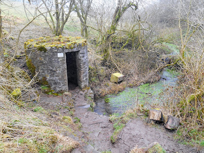
The entrance to Swildon's Hole is a small triangular shaped opening in the floor of a stone blockhouse.  When we visited in February 2018 there was no door on the blockhouse and the hatch was open, presumably because there were people down in the cave.  The water from the stream, which disappears into the ground at Swildon's Hole, reappears at Wookey Hole.

Blockhouse above entrance to Swildon's Hole
 
Entrance to Swildon's Hole
 
Two cavers prepare to enter Swildon's Hole
 
Mendip Cave Rescue Notice on Swildon's Hole Blockhouse
 
Stream entering Swildon's Hole underneath the blockhouse
Blockhouse in the summer - June 2018
 
Entrance hatch to Priddy Green Sink - obviously not used very often
 
Map of Swildon's Hole on display at Priddy Green
 
Notice about the changing barn at Manor Barn, Priddy Green