In 1697 an Act
of Parliament enabled Justices of the Peace to order the erection of inscribed
waymarkers known as guide stoops, guideposts or direction stones at the intersection of paths in remote moorland areas. These stone guide stoops, which often
resembled farm gateposts, pointed the way to the nearest market town.
From the late
17th century to the 1840s Turnpike
Trusts were set up by Acts of Parliament to improve the state of Britain’s
roads, which often became impassable in the winter months. Local groups of
wealthy people paid for improved roads to be built and then charged people tolls
for using them. The turnpike milestones of the 18th and early 19th centuries
used statute miles. At first these milestones were made of stone or were
engraved in walls of buildings but the later ones were made of cast iron. After
1767 milestones were compulsory on all turnpike roads to inform travellers, to
help coaches keep to schedules and for the calculation of charges for the
changes of horses at coaching inns.
Most milestones
and mileposts were removed or defaced at the beginning of the Second World War to
confuse the Germans in the event of an invasion and not all were replaced
afterwards. Some have been demolished more
recently during road widening schemes and others have been damaged by vehicles
colliding with them or by hedge cutting equipment. However several have survived in
Somerset.

Milestone, Cothelstone Hill

Cast iron milepost, Shoreditch, near Taunton Racecourse
Honiton 16 miles, Taunton 2 miles

Cast iron sign mounted on a wall in Curry Rivel

Cothelstone
(it's a shame they couldn't spell Bridgwater!)

Bath Turnpike Trust milepost, Widcombe, Bath

Bath Turnpike Trust's 1827 milepost on the A367 at Odd Down
This marks the boundary between the parishes of Combe Hay and Englishcombe.

This marks the former boundary between the parishes of Widcombe and Combe Hay

Simple milestone, Church Street (B3162), Winsham

Replica milestone, A396 at Wheddon Cross
It has the date 2005 on it.

A39 at Coxley near Wells
2 miles to Wells, 4 miles to Glastonbury and 18 miles to Bridgwater

Cast iron milepost on Church Street (A366),
Norton St Philip
6 miles to Trowbridge, 16 to Devizes, 17 to Wells and 105 to London

Direction stone, West Chinnock
This direction stone is located at the junction of Smoky Hole Lane and Smith's Hill and is made of Ham stone. It is thought to date from 1745 or 1749. On the south face an inscribed cuffed hand points east to EAST/NNICK (East Chinnock) and another hand points west to CREWKE/RNE ROAD. On the east face a hand points north to YEOVIL/ROAD. The distances are not given.

Milestone outside Shoreditch Farm

Replica milestone, Kingston Road, Kingston St Mary
It has the date 2007 on it.

Milestone by the side of Honiton Road in Blagdon Hill

It is very precise as to how far away Minehead is: 22 miles, 5 P (poles or perches - is is definitely a P but should it be F for furlong?) and 34 R (rods)

Bristol Turnpike Trust's 1823 cast iron milepost and an earlier milestone on the A370 at Chelvey Batch

Somerset County Council’s
1911 milepost in Clevedon Road, Tickenham

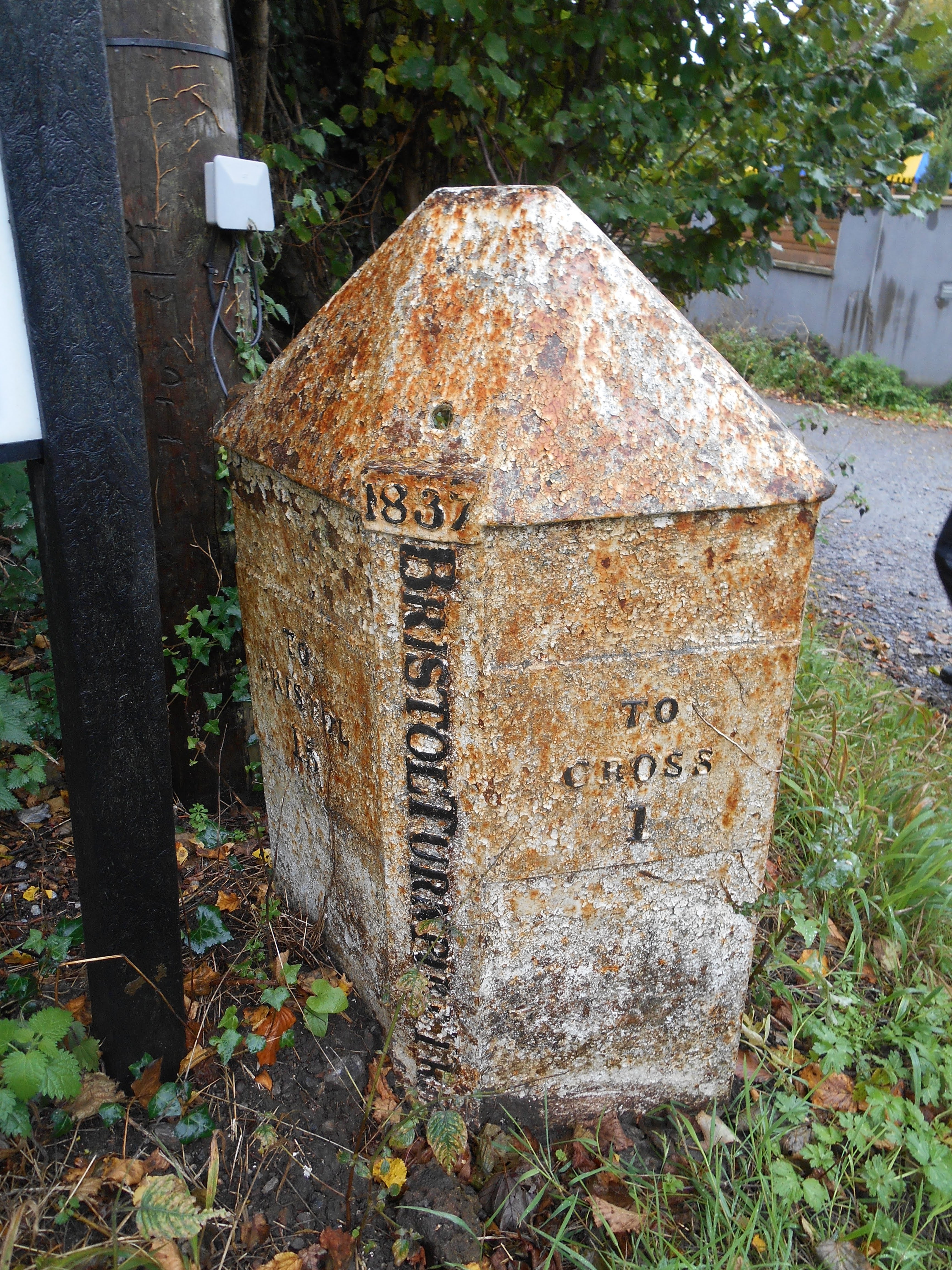
Bristol Turnpike Trust's 1837 cast iron milepost in Clevedon Road, Nailsea

Bristol Turnpike Trust Milepost on the A38 at Langford

1733 Bristol Rode guidestone at the junction of Clapton Lane and Clevedon Road, Portishead


Milestone in High Street, Ilchester
Miles to London 127, Bristol 35, Bath (illegible) 33, Wells 18, Taunton 24, Yeovil 5

A3066, Haselbury Plucknett

Cannard's Grave Road (A371), Shepton Mallet

Market Cross, Shepton Mallet

4 miles to Bridgwater

Staple Fitzpaine
5 miles to Taunton

Taunton 26, Shepton Mallet 4, Glastonbury 5

New Cross
Langport 6, Crewkerne 7
No comments:
Post a Comment