Showing posts with label Mining. Show all posts

Saturday, 2 October 2021

The Nailsea Coalfield

Nailsea hides its coal mining heritage well.  Most visitors to the town are unlikely to notice the few remaining engine and winding houses or spoil heaps.

The Nailsea Coalfield is an outlying section of the much larger Somerset and Bristol Coalfield. Coal seams in the Nailsea area, which are sandwiched between layers of pennant sandstone, are located in an arc around the north and east of the town.  The arc starts in the North Street/Union Street area of the town.  It then runs parallel to Silver Street and High Street and continues on through Nailsea Park, Trendlewood and down to Backwell Common and the railway station.  The coal measures are deepest in the centre of the arc.  The deepest mine was Golden Valley at around 620 feet deep.

Coal mining in Nailsea started in the early 16th century when it is recorded that coal was transported from Nailsea to Yatton to be burnt in a limekiln. At first the coal was only mined where it outcropped near the surface but by the mid-18th century deep pit mining had commenced.  There were 10 workable coal seams.  Some of them were up to 3 feet 6 inches thick but others were only 18 inches thick and it was barely viable to mine these thinner seams.  

Some of the Nailsea coal mines were privately owned but many of them were run by, or associated with, one company – White & Co.  This company started in 1786 as a 3 man partnership between Isaac White, Peter Cox and Joseph Whitchurch.  In 1788 Bristol glassmaker John Robert Lucas bought a share in the partnership and set up a glassworks in Nailsea, which provided a market for the coal. 

Power for winding in the mines was initially provided by horses.  Steam pumping engines were introduced in the mid-18th century.  This enabled the mining of coal measures, which couldn’t previously be exploited due to flooding.  Horses continued to be used for winding purposes until well into the 19th century.  Ponies (and young boys) were also employed below ground to haul sleds and waggons containing coal.

Tramways were built to link up some of the collieries (Youngwood/Whiteoak and Grace’s/West End) with the main railway line, which reached Nailsea in the 1840s.

Most of the coal produced was sold locally to heat houses and churches in the town and surrounding villages, to fire local lime kilns, to power the Nailsea Glassworks and in the pits themselves to fire the steam engines.

Output from the Nailsea Coalfield reached its peak in the 1850s.  In the 1841 Census there were 149 people in Nailsea and Backwell who were directly connected with coal production.  This number rose to 193 in 1851, then fell to 170 in 1861 and 70 in 1871.  It rose to 103 in 1881 but by 1891 only 16 people were employed producing coal.   Coal mines in the Nailsea area started to decline in the 1860s due to competition from larger mines in South Wales and the North of England, where the coal was cheaper and easier to extract.  Nailsea Glassworks closed in 1873 and the last Nailsea coal mine (Whiteoak) closed in 1882.

Several examples of winding and pumping houses remain, three as ruins and two as conversions into dwellings. The most obvious remains are the small winding tower in Millennium Park, which was once part of the Old Glasshouse Pit. The Middle Engine/Elms Pit complex in the Cherington Road/Oaksey Grove area of Golden Valley is now a scheduled monument. The engine house from Farler’s Pit survives in the garden of a private house on the corner of Queens Road and Station Road.  In North Lane an engine house has been converted into a cottage and Tall Cottage in Union Street was possibly formerly an engine house.

The remains of horse whims survive at Old Glasshouse Pit and Middle Engine Pit.  Spoil heaps remain from Golden Valley, Buckland’s Batch/Goddins, East End, Backwell Common and Youngs Pits.

Former Engine House on North Street, now converted to a private house

Spoil heap on Backwell Common

Remains of Old Glasshouse Pit's horse whim in Millennium Park

The ruined winding tower of Old Glasshouse Pit in Millennium Park

Spoil heap from Youngs Pit in Nailsea Park

Monday, 31 August 2020

Thomas Poole of Nether Stowey

Thomas Poole was born in Nether Stowey on 14th November 1766.  His father Thomas was a tanner and farmer.  He wanted his son to carry on his tanning business when he died, so he denied him a proper education and sent him to work as an apprentice in the tanyard from an early age.  Thomas junior educated himself and taught himself Latin and French.  In 1791 he represented the west country at a tanners meeting in London and was elected by them to speak to William Pitt about the distressed state of the tanning industry.  He returned from London as a supporter of the French Revolution. 

In 1793 Poole established the Nether Stowey Book Society. The members of the group met at The Globe Inn and bought books and exchanged books.

Thomas Poole was introduced to Samuel Taylor Coleridge for the first time in August 1794 by his relative Henry Poole of Stogursey, who brought him to Thomas's house in Castle Street.  Coleridge was on a walking tour of Somerset with the poet Robert Southey.  Thomas and Coleridge became great friends.

In 1795 there was hardship in Nether Stowey when the price of wheat increased rapidly due to the war with France.  Poole, his mother and aunt created new recipes for cheaper loaves of bread e.g. using a mixture of wheat, barley, beans and potatoes or turnips.  In 1796 Poole built a new barkhouse in Tanyard Lane.

Coleridge asked Poole to find him a house in Nether Stowey and on 1st January 1797 he moved into a house on Lime Street in Nether Stowey with his wife Sara and their baby son Hartley. In July 1797 Poole arranged for William and Dorothy Wordsworth to rent Alfoxton House on the edge of Holford.   Also in 1797 Poole met the Staffordshire potters Josiah and Tom Wedgwood and he and Josiah became lifelong friends.  Through his friendship with Coleridge and Wordsworth, Poole met several other influential people of his day: the essayist and poet Charles Lamb; the radical speaker, writer, poet, painter and political reformer John Thelwell; the essayist, critic and philosopher William Hazlitt.

Poole met the scientist and inventor of the miners' safety lamp, Humphry Davy in 1799 and Davy later became a regular visitor to Nether Stowey.

Poole went on a tour of Europe in 1802.  In Paris he met the revolutionary and writer Thomas Paine (author of The Rights of Man) and was also presented to Napoleon Bonaparte. In the same year he met the civil servant John Rickman in London and in 1804 he compiled statistics for Rickman that were to be used to implement the poor laws.

In 1806 Poole founded the Nether Stowey Female Friendly Society.  Members paid what they could afford and in return they received financial support when they were sick, gave birth, were widowed or in their old age. Poole met the essayist Thomas de Quincey in 1807.

In 1807 Thomas tried unsuccessfully to reopen the Dodington copper mine, which had closed down in 1891.  He tried again in 1816 and built two new engine houses but the mine closed for the last time in 1821.

Poole donated a piece of land and paid for the building of a village school in Nether Stowey in 1812-13.  The school was large enough to educate up to 200 local children.  It was used as a school until 1979 when a new one was built and the building now houses the public library.

From 1814 until his death, Poole was a justice of the peace for Somerset.  

To encourage local people to save money and give them access to banking services, Thomas founded the Quantock Savings Bank in Lime Street, Nether Stowey in 1817.  The bank was in business until 1884.

Thomas Poole never married.  He lived in a house now called Poole House in Castle Street, Nether Stowey until 1802 when he gave the house to Thomas Ward, who was his partner in the tanning business.  Poole bought another house in St Mary Street, now called The Old House.  He lived there until his death.  He amassed a large library of books. Many people in the Nether Stowey area were suspicious of his radical views.  Although he was a great philanthropist and had many friends, he had a short temper and could sometimes be abrupt and overbearing.

Thomas Poole died of pleurisy in Nether Stowey on 8th September 1837 aged 72.  He was buried in the churchyard of St Mary's Church in the village.

Portrait of Thomas Poole in the Museum of Somerset in Taunton

Poole House in Castle Street, Nether Stowey

The Old House, St Mary Street, Nether Stowey

Quantock Savings Bank, Lime Street, Nether Stowey

Quantock Savings Bank, Lime Street, Nether Stowey

Old School, Nether Stowey (now the public library)

Thomas Poole's gravestone in St Mary's churchyard

Thomas Poole's Memorial inside St Mary's church

Monday, 14 January 2019

Smitham Chimney, East Harptree Woods

Smitham Chimney and the pond next to it are the only visible remains of a lead smelting plant.  The stone and brick chimney is located on Smitham Hill in the middle of East Harptree Woods.  A public footpath runs through the site.  The grid reference for the site is ST 554 546.

Lead mining in the Mendips dates back to at least the Iron Age and it continued in the Roman period and on into medieval times.  It reached its peak in the late 16th/early 17th centuries but by the 18th century most of the easily available lead had been mined and flooding in the shafts became an issue.  Silver, zinc, iron, ochre, manganese and calamine were also mined at various locations on the Mendip Hills. At various periods lead was mined at East Harptree; Velvet Bottom at Charterhouse; Priddy; Stockhill and Chewton Mendip.  At East Harptree lead was mined from veins in the Carboniferous Limestone and zinc and manganese were mined from veins in the Dolomitic Conglomerate.

In 1867 a group of Cornish miners formed the East Harptree Lead Works Company, in order to re-smelt the heaps of slag and slimes left by previous mining ventures.  New techniques developed in Cornwall meant that they could now release lead that earlier miners had not been able to remove from the ore. The lead produced was used for the shot in guns.  The chimney vented the smoke produced by five lead condenser flues.  These are clearly shown on an Ordnance Survey map of 1883 stretching out in a north easterly direction from the chimney.  They have subsequently been planted over with conifers and are now barely visible.  Areas of what is known in the Mendips as "gruffy ground" (uneven pockmarked mined ground) can apparently be seen in the woods.  The pond was originally a reservoir for the lead smelting works.

The site at East Harptree closed in 1875 and all the buildings except the 70 feet high chimney were later demolished.  The chimney was renovated in 1914 and again in the 1973 by the Mendip Society and Somerset County Council. 

A brickworks is shown on the 25" Ordnance Survey map of 1883 on the eastern side of the lead works.  However it was already disused by this time.

Maybe it is an optical illusion but the top of the chimney looks like it is leaning to the left?

Doorway at the bottom of the chimney:
it looks like lots of birds nest inside, judging by the huge pile of sticks behind the grill!

Smitham Chimney

Smitham Chimney and pond

Reflection of Smitham Chimney in the pond

Smitham Chimney and Pond

Pond

Saturday, 11 February 2017

West Somerset Mineral Railway

The West Somerset Mineral Railway was built between 1857 and 1864 to transport iron ore from the top of the Brendon Hills down to the port of Watchet.  It was then shipped across the Bristol Channel to South Wales and smelted at Ebbw Vale.  It was not a great success commercially and the mines closed in 1883.  The railway, which was 11 miles long, closed in 1898.

Iron ore had probably been mined on the Brendon Hills intermittently since the Iron Age.  The mines were open trenches on the surface, which followed the lines of the ore lodes.  In 1839 Sir Thomas Lethbridge, who owned an estate on the Brendon Hills, opened Lothbrook Mine. He proposed the building of a tramway from the Brendon Hills down to Watchet but nothing came of this.

The Ebbw Vale Company experienced rapid growth in demand for wrought iron for railway tracks and by the 1850s they were running short of iron ore.  They looked to the Brendon Hills as a new source of supply.  The iron ore in the Brendon Hills is low in sulphur and phosphorus but high in manganese.  This was the type of ore needed for the Bessemer process of making steel, which was used in Ebbw Vale from the 1860s.

The Brendon Hill Mining Company was formed in 1849 and obtained a 2 year mining licence from Sir Walter Trevelyan, who owned a large amount of land on the Brendon Hills.  In 1853 the Brendon Hill Mining Company, which was by this time a partnership between Thomas Brown and Joseph Robinson, acquired the rights to mine in the Brendon Hills.  In 1854 mines were opened at Ralegh's Cross, Gupworthy and Bearland Wood.   Between 1855 and 1861 Colton Pits, Carnarvon, Eisenhill and Burrow Farm mines were opened.  Morgan Morgans from South Wales became the General Manager of the Brendon Hills Mines in 1858 and engineer to the West Somerset Mineral Railway.  Further mines were opened 1864-6: Roman, Carew, Withiel Hill and Smallcombe.  

A mining settlement grew up near the top of the Incline at Brendon Hill from 1855-67.  Houses, churches, chapels, schools and shops were built.  Houses for miners were also built at Gupworthy, Sminhays and Ralegh's Cross.

Construction of the railway began at Watchet in 1856.  The first train ran from Watchet to Roadwater in May 1857 and by the end of the year the line had reached the bottom of the Incline at Comberow.  The Incline was designed by Welshman Rice Hopkins with a gradient of 1:4.  Rice Hopkins died in 1857 before the line had got as far as Comberow.  The railway was completed to the top of the Incline in 1861, including the two winding drums needed to haul the trains up it.  The line was extended to Goosemoor in 1864.  

In 1865 the West Somerset Mineral Railway was opened to passenger traffic from Comberow to Watchet, with additional stations at Roadwater and Washford.  

At Watchet Station the iron ore was loaded into horse drawn waggons.  The horses pulled the wagons on rails over Market Street and on to the quay.   Until 1875 the ore was shovelled into boats at Watchet by hand.  Then hydraulic tippers were installed. 

The peak year for iron ore production was 1877 when 47,000 tons was produced.  However the iron ore deposits of the Brendon Hills are fragmented and were expensive to work.  In the late 1870s the price of steel collapsed due to an economic depression and imports of cheaper iron from Spain.  At around the same time the Bessemer process was replaced by the Gilchrist-Thomas' method, which didn't require ore low in phosphorus. 

After the closure of the railway line in 1898 the line became derelict but in 1907 the Somerset Mineral Syndicate leased the line and opened some of the mines again, as steel prices had risen.  However it was not successful and the company was wound up in 1910.  The last trains to run on the Mineral Line did so in 1913, as part of a trial into automatic railway signalling by an Australian named Arthur Angus. In 1916 the UK government requisitioned the track for use in the First World War.   The West Somerset Mineral Railway Company was finally wound up in 1925.

In 2008 the West Somerset Mineral Railway Project conserved the remains of the Winding House at the top of the Incline, Bearland Wood Ventilation Flue and the Langham Hill Engine House.  This project was funded by the Heritage Lottery Fund. The Burrow Farm Engine House was conserved by Exmoor National Park Authority in 1990.  The former station house, goods and engine sheds can still be seen close to Watchet Harbour.


Winding House at the top of the Incline
Inside the Winding House at the top of the Incline

Artist's impression of what the area around the Winding House at the top of the Incline looked like when it was in use

There is a small parking area immediately to the west of the Winding House on the B3224.  However I wouldn't advise trying to turn right out of it, as you can't see anything and the traffic is usually going very fast at this point.   Grid reference: ST 023 345.

Burrow Hill Engine House
Burrow Farm Engine House (grid reference ST 008 345), which is a Cornish style engine house, is located on private land.  There is a permissive footpath to it from an unclassified road at Naked Boy's Bridge.  There is only parking for one car there.  The footpath is closed in April every year and no dogs are allowed at any time, due to the presence of sheep.  The permissive path is a dead end, so you have to walk back the same way.

Burrow Hill Engine House
The small building on the left of the photo is the remains of a drying shed, which was used to dry miners' clothing.


Inside Burrow Hill Engine House

Line of the Mineral Railway near Burrow Hill

Brendon Hill Chapel
This chapel was originally called Beulah Bible Christian Chapel.  It was built in 1861 but was derelict by 1900.  It reopened in 1910 and is still in use today as a Methodist Church.  The Bible Christians amalgamated with the United Methodist Church, which in turn reunited with the Primitive and Wesleyan Methodists in 1932.  Grid reference: ST 028 343.

Remains of Langham Hill Engine House
Langham Hill Engine House (grid reference SS 977 356) was built in 1866.  It housed a second-hand steam beam engine brought over from South Wales.  This was used to pump water from the mine and to bring the ore to the surface. In 1878 it was dismantled and moved by train to Burrow Farm where the remains of it still stand.  There is a large car park at Chargot Wood on the north side of the B3224.  Langham Hill Engine House is about 300 metres north east of the car park just off a forestry track.  The Bearland Wood Ventilation Flue is about the same distance in a north westerly direction from the car park.
 
Footings of Langham Hill Engine House

Bearland Wood Ventilation Flue
Bearland Wood Ventilation Flue (grid reference SS 973 357) was built in 1860 to remove poisonous gases and smoke and fumes from the rock blasting from the mine below.  A fire was lit at the base of the chimney stack, which drew contaminated air up a vertical shaft from the mine and thus allowed fresh air to flow into the mine from the adit.  No iron ore was found in the Bearland Wood adit and the mine and flue were abandoned in 1864.

 Bearland  Wood Ventilation Flue
 
Start of the Old Mineral Line footpath in Watchet
 
Remains of the Old Mineral Line in a private Roadwater Garden
 
Former Station House, Watchet Harbour
 
Former Goods Shed, Watchet Harbour

Section of track preserved at Watchet Harbour

Hill House at Brendon Hill
This was formerly the Mines Office

Artist's impression of the village of Brendon Hill when the Mineral Line was in use

Bottom of the Incline at Comberow

Morgan Morgans

Tuesday, 2 August 2016

Wheal Eliza and the Murder of Anna Maria Burgess

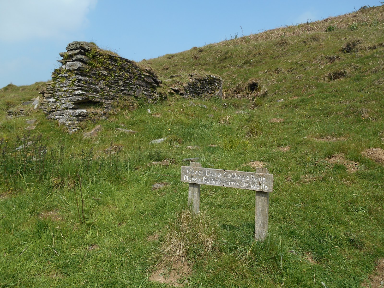
Wheal Eliza was a copper mine on the banks of the River Barle about a mile downstream from Simonsbath.  It opened in 1845 and was initially called Wheal Maria.  It had two leats and a large water wheel by 1846.  The entrance was a stone lined adit, which led to a 300 foot shaft.  By 1851 9 miners were employed at the site.  6 of them lived in a cottage on the site.  Little copper was produced and the mine closed in around 1857.  The remains of the workers' cottage, one of the leats, the space where the water wheel was once located and the mine shaft can still be seen. 

In the 1850s William Burgess lived with his wife and three children in a cottage in White Water Combe just over half a mile to the east of Wheal Eliza.  Then in 1857 Mrs Burgess died.  The two oldest children went into service at local farms but the Burgess's youngest child Anna Maria was only 6, so she went with her father into lodgings at Galleon House in Simonsbath.  However William Burgess resented having to pay a local woman 2s 6d to look after Anna.  He would rather have spent the money on alcohol.  William killed Anna in July 1858 to save the money and told everyone she had gone to live with relatives in Porlock.  

However the local vicar William Thornton and others didn't believe him and made checks in Porlock.  Reports of a blue light seen above Wheal Eliza led William Thornton to suspect that was where Anna's body had been dumped.  The mine was pumped out and after a few weeks Anna's body was found.  William Burgess had fled to South Wales but was captured there and brought back to Exmoor.    He admitted the murder of his daughter and was convicted and sentenced on 20th December 1858.  He was hanged on 7th January 1859.  Anna was buried in an unmarked grave in St Luke's Churchyard in Simonsbath.  The Exmoor Society later erected a headstone but as the location of the actual grave is unknown, they chose a suitable spot.


The water wheel was located in this space on the opposite side of the River Barle to the mine

Remains of the leat leading to the water wheel

Remains of Wheel Eliza and its spoil heaps from across the River Barle

Ruined Cottage at Wheal Eliza

Workers' Cottage ruins

Fenced off mine shaft.  The leat can be seen on the far bank

The Burgess's cottage in White Water Combe was located around here.  There are a few heaps of stones but no sign of a cottage.

Approximate location of the Burgess's cottage in White Water Combe

Anna Maria Burgess's headstone in St Luke's Churchyard, Simonsbath
The inscription reads "Anna Maria Burgess. Died in tragic circumstances, July 1858.  Aged 6 years." 

Further reading: The Murder of Anna Maria: The True story of William Burgess and the Wheal Eliza Mine by Gail Crane, Aller Books, 2023