Wednesday 15 December 2021

Second World War Bomber Crash Memorial in Bridgetown Wood

 A memorial stone has recently been placed in Bridgetown Wood, by the side of the bridlepath, which runs between Bridgetown and Howetown Farm.  It commemorates the Stirling bomber, which crashed nearby, just after midnight on 27th January 1944.  All 8 men onboard the plane were killed and the wreckage was scattered for up to 3.5 miles in an easterly direction.  

The Stirling bomber (serial number EH933) was part of 1660 Heavy Conversion Unit.  It was on a training exercise and had flown from RAF Swinderby in Lincolnshire.  Seven of the men were members of the RAF Volunteer Reserve and the navigator was a member of the Auxiliary Air Force.  The plane was undertaking a cross-country navigation exercise and was on the fourth part of its journey, which involved flying from Sidmouth to Ilfracombe.  However it flew off course and then dived steeply and broke up in the air. The main part of the aircraft crashed at Bridgetown.  The names of the men who died are recorded on the memorial:

  • Sgt Ronald A Partridge
  • Sgt Claude V Tomkinson
  • Sgt Thomas H Jones
  • Sgt Ben Ackroyd
  • Sgt Alfred Thursby
  • Sgt Herbert Hewitt
  • Sgt John Kerry
  • Sgt Richard Street
Memorial in Bridgetown Wood

Thursday 2 December 2021

Guglielmo Marconi

Guglielmo Marconi was born in Bologna, Italy. His father Giuseppe Marconi was Italian but his mother Annie Jameson came from County Wexford in Ireland.  As a boy he was very interested in physical and electrical science and in 1895 he succeeded in sending wireless signals over a distance of 1.5 miles on his father’s estate at Pontecchio near Bologna.

In 1896 Marconi brought his equipment to England because the Italian government was not interested in his work.  He was introduced to Sir William Preece, who was Chief Engineer at the Post Office.  In the same year he was granted the world’s first patent for a system of wireless telegraphy.  He demonstrated his system successfully in London and on Salisbury Plain.

On 13th May 1897 Marconi and his assistant George Kemp successfully transmitted long wave wireless messages between Lavernock Point on the coast of South East Wales and Flat Holm Island in the Bristol Channel, a distance of 3 miles. These were the first ever wireless messages to travel over open water.  On 18th May 1897 they succeeded in transmitting wireless messages from Lavernock Point across the Bristol Channel to Brean Down, a distance of nearly 9 miles.

In July 1897 Marconi formed the Wireless Telegraph and Signal Company Limited This was re-named Marconi's Wireless Telegraph Company Limited in 1900. 

In 1899 Marconi established wireless communication between France and England across the English Channel. In December 1901, in order to prove that wireless waves are not affected by the curvature of the Earth, Marconi transmitted the first wireless signals across the Atlantic between Poldhu in Cornwall and St. John's in Newfoundland, Canada - a distance of 2100 miles.  In 1907 he opened the world’s first commercial transatlantic wireless telegraph service between Glace Bay in Nova Scotia and Clifden in County Galway, Ireland.

In 1909 Marconi was awarded the Nobel Prize in Physics jointly with German physicist Ferdinand Braun, "in recognition of their contributions to the development of wireless telegraphy".  He served in the Italian Army during the First World War and during this time and afterwards he continued his experiments into short wave wireless communication. In 1923 he successfully conducted trials between Poldu in Cornwall and his yacht Elettra, which was cruising in the Atlantic Ocean and Mediterranean Sea over 1,400 miles away.  This began the development of shortwave wireless communication, which is the basis of most modern long-distance radio communication. In 1924 Marconi’s company obtained a contract from the Post Office to establish shortwave communication between England and the countries of the British Empire.

In the 1930s Marconi conducted experiments in Italy using microwaves and in 1935 he gave a practical demonstration in Italy of the principles of radar.  He died at his home in Rome on 20th July 1937 following a series of heart attacks.

Guglielmo Marconi’s achievements are commemorated by numerous monuments and plaques in various locations around the UK where he lived, worked and conducted experiments.  He has at least 26 roads named after him in Great Britain, including ones in Weston-super-Mare, Portishead, Highbridge and Penarth.

Further Reading:
Marconi: A Biography: W.P. Jolly.  Constable, 1972
My Father, Marconi: Degna Marconi.  Frederick Muller, 1962

Marconi Road, Portishead

Plaque in the Italian Gardens, Weston-super-Mare 
It commemorates Marconi’s achievements in the area in 1897.

Brean Down

Monument on Flat Holm commemorating Marconi's visit in 1897

Thursday 25 November 2021

Edith Cavell

Edith Louisa Cavell was born on December 4th 1865 in the village of Swardeston in Norfolk, where her father Frederick was the vicar for 45 years. After being educated at home for several years, Edith boarded at Belgrave House School in Elton Road, Clevedon from 1883-84. She then attended schools in London and Peterborough. In 1889 she became governess to a family in Brussels and she remained in this post for six years. She returned to England in 1895 to nurse her seriously ill father and she then decided to train as a nurse. She trained at the Royal London Hospital and then worked at various hospitals in London and Manchester.

In 1907 Edith was appointed as director of a new nurses’ training school in Brussels, which had just been set up by Dr Antoine De Page. She successfully persuaded potential recruits and members of her committee that nursing was a respectable profession and one which required professional training.

After the German occupation of Belgium in late 1914, Edith became involved in an underground group formed to help British, French, and Belgian soldiers reach the Netherlands, which was a neutral country. The soldiers were sheltered at the Berkendael Institute, which had become a Red Cross hospital.  They were provided with money and guides by a Belgian called Philippe Baucq.  About 200 men had been helped before Edith and several others were arrested in August 1915 by the Germans.

The group of nine people was brought before a court martial on October 7th, 1915, accused of assisting the enemy and of trying to damage the German war effort. Edith Cavell made a full confession and was sentenced to death on October 9th, along with four others. The remaining four were sentenced to hard labour.  Edith Cavell and Philippe Baucq were executed by a firing squad on October 12th 1915 in Brussels, despite the efforts of the American and Spanish ministers to secure a reprieve. Edith’s execution on a charge, which did not include espionage, was considered outrageous and was widely publicised by the Allies.

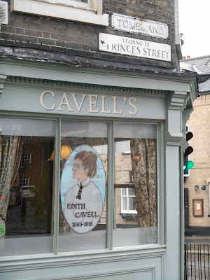
After the war there was a funeral service for Edith Cavell at Westminster Abbey and on 15th May 1919 her body was reburied on the outside of the south east corner of Norwich Cathedral.  She is commemorated on the Swardeston village sign and by a statue in St Martin’s Place in London. There are busts of her at the London Hospital Museum; in Brussels; Melbourne in Australia and Norwich.  She also has many streets in the UK and across the world named after her and a bar in Tombland, Norwich There is a blue plaque on 1 Elton Road, Clevedon, commemorating the time she spent at school in Clevedon.

Further Reading:

Edith Cavell: Faith before the Firing Squad: Catherine Butcher.  Monarch Books, 2015

Edith Cavell: Nurse, Martyr, Heroine: Diana Souhami.  Quercus Publishing, 2015

Blue plaque outside 1 Elton Road, Clevedon

1 Elton Road, Clevedon

Edith Cavell's memorial outside Norwich Cathedral

Bust of Edith Cavell, Norwich

Cavell’s Bar with a stained glass window of Edith, Tombland, Norwich

Friday 12 November 2021

St Michael's Church, Raddington

St Michael's Church at Raddington is an unspoiled gem of a church.  There is no road access to it: it is only accessible by footpaths from the lanes to the north and the south.  The only lanes nearby are all very narrow and there is nowhere to park a car.  The church is situated a mile north of the B3227 road at Petton. The grid reference of the church is ST020 260.

The church may date back as far as the 9th century, as it has the remains of a Holy Water stoup in the porch and these were very common in early churches but were not popular in medieval times. The church  was definitely there at the beginning of the 13th century.   The style of the church is early English and the site of the church was probably formerly a pagan sacred site.

The interior of the church contains the following features of particular interest:

  • some medieval floor tiles
  • oak box pews and panelling, which date from the second half of the 19th century
  • a 13th century octagonal Purbeck type font with a later cover
  • an early 15th century rood screen with carvings of foliage and bunches of grapes.  This was made by the same carver who worked at Uffculme church in Devon
  • 19th century roof bosses, including one of a green man, in the chancel
  • wall paintings of the Ten Commandments, Lord's Prayer and part of Psalm 150, which date from the second half of the 17th century.  These were discovered in 1982 and uncovered in 2012.
  • impressive porch door with strap hinges dating from 1350-1370
  • 14th century barrel wagon roof in the nave.
  • the altar, which dates from 1921, is a memorial to the men of the parish who died in the First World War
  • 3 bells, two dating from the 14th or early 15th century and one from 1657
 The ruins of the parish poor house can be seen in the north east corner of the churchyard.

St Michael's Church, Raddington from the hill above the church

St Michael's Church, Raddington

Rood screen with the altar beyond

Close up of part of the rood screen

Wall painting - the Lord's Prayer

Medieval floor tile

Jug specially made for the church in 1996

Porch Door

Plaque on the tower with the date it was restored (1675) and the churchwarden's initials.

Green man on a roof boss in the chancel

Nave with barrel wagon roof, rood screen and font

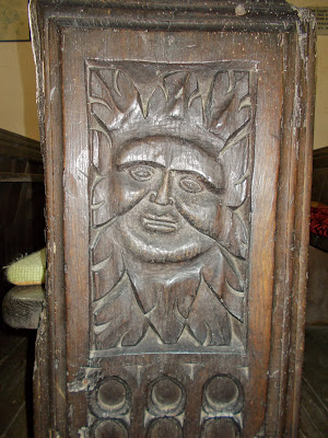
Green Man on bench end

Saturday 30 October 2021

Walter Bagehot of Langport

Walter Bagehot was born in Langport on 3rd February 1826.  He became an economist and political analyst and he was one of the most influential journalists in the mid-Victorian period. His parents were Thomas Watson Bagehot and Edith Stuckey.  Several generations of Walter's father's family had been general merchants and his mother's uncle, Vincent Stuckey, was in charge of the largest bank in the West of England.

He attended Langport Grammar School and at the age of 13 he was sent to Bristol College.  There he learnt about mathematics, philosophy, literature, natural sciences and the classics. He then attended University College London.  While there he made several long-term friends, including the poet Arthur Hugh Clough, Richard Holt Hutton (who later became the editor of The Spectator), lawyer and diarist Henry Crabb Robinson and the poet Samuel Taylor Coleridge.  He graduated with first class honours in 1846 and was awarded a masters degree in 1848, along with the university's gold medal in moral and intellectual philosophy.

Walter then studied law for 3 years but didn't like it.  He was in Paris in 1851 at the time of Louis Napoleon's coup d'etat and wrote a supportive article about it.  This convinced him that he could write and he produced many literary essays, studies of leading political figures and articles about economics while working for Stuckey's Bank.  These were noticed by James Wilson, who was an MP, financial secretary to the treasury in Lord Palmerston and founder of The Economist magazine.  He got to know James Wilson's eldest daughter Eliza and he married her in April 1858.  After their marriage they lived near Clevedon and later in London.  They had no children.

By 1860 Walter was manager of the Bristol branch of Stuckey's Bank.  During this year James Wilson died in India and Walter gained control of The Economist. For the next 17 years he wrote the main article every week for the magazine and transformed it into one of the world's most important financial and political publications.

Walter Bagehot described himself as a conservative liberal.  He believed that rapid urbanisation and industrialisation were creating social problems in Britain.  He also took a great interest in international affairs.  In 1867 he published a book entitled The English Constitution.  In it he examined how the British government really operated and in whose hands true power was held.  He was one of the first people to observe the power of the Cabinet.  He was friends with both the Liberal William Ewart Gladstone and the Conservative Lord Carnarvon.  He tried unsuccessfully to get elected as an MP for Manchester, Bridgwater and London University (he was a poor public speaker).

In 1873 Walter Bagehot published Lombard Street. This publication argued for a larger central reserve to be controlled by the Bank of England.  However, it also contained the beginnings of the modern theory of central banking and exchange control.

Walter Bagehot's health began to worsen in the 1870s.  He suffered from recurrent respiratory infections and migraines and his vision and heart began to fail.  On 24th March 1877 he died of a lung infection while visiting his father at Herd's Hill near Curry Rivel.  He was buried in the family grave at All Saints' Church in Langport.

Bank House, Cheapside where Walter Bagehot was born

Plaque commemorating Walter Bagehot above the front door of Bank House

Walter Bagehot Memorial Window, All Saints' Church, Langport

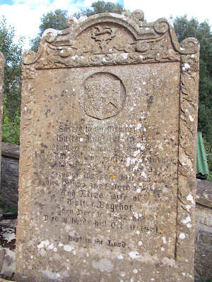
Walter Bagehot's grave in the churchyard of All Saints' Church, Langport

Walter Bagehot's gravestone

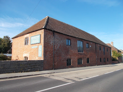
Bow Wharf Warehouse, Langport
This was built by the Parrett Navigation Company, which was owned by Vincent Stuckey and Walter Bagehot

Saturday 2 October 2021

The Nailsea Coalfield

Nailsea hides its coal mining heritage well.  Most visitors to the town are unlikely to notice the few remaining engine and winding houses or spoil heaps.

The Nailsea Coalfield is an outlying section of the much larger Somerset and Bristol Coalfield. Coal seams in the Nailsea area, which are sandwiched between layers of pennant sandstone, are located in an arc around the north and east of the town.  The arc starts in the North Street/Union Street area of the town.  It then runs parallel to Silver Street and High Street and continues on through Nailsea Park, Trendlewood and down to Backwell Common and the railway station.  The coal measures are deepest in the centre of the arc.  The deepest mine was Golden Valley at around 620 feet deep.

Coal mining in Nailsea started in the early 16th century when it is recorded that coal was transported from Nailsea to Yatton to be burnt in a limekiln. At first the coal was only mined where it outcropped near the surface but by the mid-18th century deep pit mining had commenced.  There were 10 workable coal seams.  Some of them were up to 3 feet 6 inches thick but others were only 18 inches thick and it was barely viable to mine these thinner seams.  

Some of the Nailsea coal mines were privately owned but many of them were run by, or associated with, one company – White & Co.  This company started in 1786 as a 3 man partnership between Isaac White, Peter Cox and Joseph Whitchurch.  In 1788 Bristol glassmaker John Robert Lucas bought a share in the partnership and set up a glassworks in Nailsea, which provided a market for the coal. 

Power for winding in the mines was initially provided by horses.  Steam pumping engines were introduced in the mid-18th century.  This enabled the mining of coal measures, which couldn’t previously be exploited due to flooding.  Horses continued to be used for winding purposes until well into the 19th century.  Ponies (and young boys) were also employed below ground to haul sleds and waggons containing coal.

Tramways were built to link up some of the collieries (Youngwood/Whiteoak and Grace’s/West End) with the main railway line, which reached Nailsea in the 1840s.

Most of the coal produced was sold locally to heat houses and churches in the town and surrounding villages, to fire local lime kilns, to power the Nailsea Glassworks and in the pits themselves to fire the steam engines.

Output from the Nailsea Coalfield reached its peak in the 1850s.  In the 1841 Census there were 149 people in Nailsea and Backwell who were directly connected with coal production.  This number rose to 193 in 1851, then fell to 170 in 1861 and 70 in 1871.  It rose to 103 in 1881 but by 1891 only 16 people were employed producing coal.   Coal mines in the Nailsea area started to decline in the 1860s due to competition from larger mines in South Wales and the North of England, where the coal was cheaper and easier to extract.  Nailsea Glassworks closed in 1873 and the last Nailsea coal mine (Whiteoak) closed in 1882.

Several examples of winding and pumping houses remain, three as ruins and two as conversions into dwellings. The most obvious remains are the small winding tower in Millennium Park, which was once part of the Old Glasshouse Pit. The Middle Engine/Elms Pit complex in the Cherington Road/Oaksey Grove area of Golden Valley is now a scheduled monument. The engine house from Farler’s Pit survives in the garden of a private house on the corner of Queens Road and Station Road.  In North Lane an engine house has been converted into a cottage and Tall Cottage in Union Street was possibly formerly an engine house.

The remains of horse whims survive at Old Glasshouse Pit and Middle Engine Pit.  Spoil heaps remain from Golden Valley, Buckland’s Batch/Goddins, East End, Backwell Common and Youngs Pits.

Former Engine House on North Street, now converted to a private house

Spoil heap on Backwell Common

Remains of Old Glasshouse Pit's horse whim in Millennium Park

The ruined winding tower of Old Glasshouse Pit in Millennium Park

Spoil heap from Youngs Pit in Nailsea Park

Saturday 18 September 2021

Poets' Walk, Clevedon

The town of Clevedon has connections to two of England’s best known poets. Poets’ Walk is a popular footpath which runs along the coast and around Wain’s Hill and Church Hill at the southern end of Clevedon.  The walk is said to have inspired poets such as Alfred Tennyson, Samuel Taylor Coleridge and William Makepeace Thackeray, who visited the town.  The formal path which exists today was constructed in 1929. Poets’ Walk was designated as a Local Nature Reserve in 1993.

Poets' Walk signpost


Poets' Walk

Poets' Walk

Poets' Walk

The Sugar Lookout is a feature on Poets’ Walk. It was built by Ferdinand Beeston in around 1835.  It is said to have been used in the mid-19th century by a family of sugar importers called Finzel to look out for ships sailing up the Bristol Channel, which were carrying sugar from the West Indies.  It later fell into ruin but has recently been restored.

Sugar Lookout overlooking the Bristol Channel

Samuel Taylor Coleridge and his wife Sarah spent the first few months of their married life in a cottage on Old Church Road in Clevedon in 1795.

Coleridge Cottage, Old Church Road, Clevedon

In the mid-18th century the author William Makepeace Thackeray was a frequent visitor of the Elton Family, who lived at Clevedon Court.  He is best known as a novelist but he did also write some poetry.

Alfred Tennyson had a close friend at Cambridge University called Arthur Hallam.  Arthur’s mother was a member of the Elton family of Clevedon Court.  Arthur, who was a poet and essayist, was engaged to marry Tennyson’s sister Emily but he died suddenly in Vienna in 1833 at the age of 22.  His body was brought back to England and he was buried in the family vault at St Andrew’s Church in Clevedon.  In 1850 Tennyson wrote a poem called In Memorium in tribute to his friend.  In the same year he made his first visit to Clevedon.  The house on Old Church Road in Clevedon, where he is said to have stayed, is called Tennyson House.   A nearby road is called Tennyson Avenue.

Tennyson House, Old Church Road

Tennyson Avenue, Clevedon

St Andrew's Church, Clevedon

Wednesday 1 September 2021

Goblin Combe

Goblin Combe is a gorge, which was formed during the last ice age by melting snow and ice cutting into limestone. It is located to the east of the village of Cleeve. The site is comprised of a steep sided dry valley with extensive areas of limestone scree, areas of semi-natural ancient woodland, unimproved calcareous grassland and limestone heath.  These types of habitat are rare in England and Goblin Combe was designated as a Site of Special Scientific Interest in 1999.  How the valley came to be called Goblin Combe is not entirely certain.  In the past it was also known as Gobble Combe and Eagle’s Combe

Most of Goblin Combe and the limestone grassland to the north of it is a nature reserve, which is owned and managed by Avon Wildlife Trust.  A public footpath runs along the bottom of the combe and there are a number of other permissive paths in the nature reserve and in the adjacent woods at the east end of the combe.

The woodland consists mainly of oak and ash trees with some beech, field maple, yew, whitebeam and hazel. In the dim light at the bottom of the combe ferns such as hart’s tongue and the rarer limestone and moonwort ferns grow. The nationally scarce stinking hellebore grows on the limestone screes. 

Over 30 types of butterfly have been found in the vicinity of Goblin Combe, including some rare varieties: grizzled and dingy skippers; silver washed and dark green fritillaries; purple and green hairstreaks; brown argus, grayling and white admiral.  Dormice and greater horseshoe bats also live in the combe.  Visitors are however unlikely to encounter any goblins! 
The ramparts of an ancient hillfort can be seen at Cleeve Toot to the north west of Goblin Combe.  It is thought to date from the late Bronze or early Iron Age.   150 metres to the north of the hillfort are the remains of another smaller ancient settlement.

Goblin Combe Environment Centre, which was located in a Victorian former school building on Plunder Street at the west end of the combe, provided learning and outdoor experiences for schools, clubs, youth and community groups but closed down in 2018.  The future of the building is currently uncertain.

The peace and quiet of the combe is broken intermittently by planes flying low overhead, as Goblin Come is very close to the western end of Bristol Airport’s runway.

Top of the limestone cliffs on the north side of the gorge

Public footpath along the bottom of Goblin Combe

Permissive path up the side of Goblin Combe

Seat at the bottom of Goblin Combe

Steep side of Goblin Combe

Goblin Combe Environment Centre

Plane coming into land at Bristol Airport seen from the edge of the woods at the east end of Goblin Combe

Saturday 14 August 2021

RAF Culm Head

The airfield at RAF Culm Head was constructed in 1940-41.  It was initially called RAF Church Stanton.  It was the first of 3 airfields to be built on the plateau at the top of the Blackdown Hills (the others were RAF Upottery/Smeatharpe and RAF Dunkeswell).  It was brought into service in June 1941 to provide shelter from bombing raids for aircraft, which were normally based at RAF Exeter but it was not officially opened until 1st August 1941.  

The first fighter squadrons to be based at RAF Church Stanton were with the Polish 2nd Fighter Wing (nos 302, 306 and 312).  They flew Mk II Hurricanes and later Spitfires Mk V.  They helped to defend the cities of Exeter and Bristol.  A Research Flight also conducted barrage balloon cable cutting experiments from Culm Head.

In June 1942 the Poles were replaced by Czechoslovakian Squadrons (nos 312 and 313), who flew Spitfires from here until June 1943.  In December 1943 the name of the airfield was changed from RAF Church Stanton to RAF Culm Head, to avoid confusion with other airfields with Church as a prefix e.g. Fenton and Broughton. 

The next occupants were the Naval Fighter Wing (Squadrons no 894 and 897) with Seafire IIIs.  They pursued enemy shipping in the English Channel and provided fighter cover for RAF Typhoon squadrons.

In March 1944 No 156 Squadron were based at Culm Head for a month with Mark IX Spitfires.  They were replaced by 610, 286  and 587 Squadrons with Mark XIV Spitfires.

After D-Day (6th June 1944), in July 1944 126, 131 and 616 Squadrons arrived to act as bomber escorts and to conduct attacks ahead of the arrival of ground troops in parts of France.  616 Squadron were equipped and trained with two Bristol Gloster Meteor fighters.  These were the allies first operational jet-propelled aircraft.

RAF Culm Head was placed under care and maintenance by November 1944.  It became active again in January 1945 when it was used by Flying Training Command when it was used as a satellite to RAF Exeter and Headquarters for No 3 Glider Training School.  They used it until July 1945 when it returned to care and maintenance status.  It was closed down in August 1946.

Map showing the layout of RAF Culm Head

Blister Hangar
This was used for the storage and maintenance of small aircraft

Pillbox with loopholes for rifles and machine guns

Key-hole shaped Gun Pit
This is the best preserved of 8 brick-lined gun pits located around the edges of the airfield. 


Aircraft Fighter Pens
These were designed to house two twin-engined aircraft

Aircraft Fighter Pens

Flight Offices